Hanasaki Station (Hokkaido)
 From Wikipedia the free encyclopedia
Hanasaki Station 花咲駅 | |
|---|---|
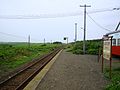
 The station structure in August 2010 | |
| General information | |
| Location | Nemuro-shi, Hokkaido Japan |
| Operated by | |
| Line(s) | ■ Nemuro Main Line |
| Distance | 438.2 km from Takikawa |
| Platforms | 1 side platforms |
| Tracks | 1 |
| Other information | |
| Status | Closed |
| History | |
| Opened | 5 August 1921 |
| Closed | 25 March 2016 |
| Location | |
 Hanasaki Station Location within Japan | |
Hanasaki Station (花咲駅, Hanasaki-eki) was a railway station on the Nemuro Main Line in Nemuro, Hokkaido, Japan, operated by Hokkaido Railway Company (JR Hokkaido). Opened in 1921, it closed in March 2015.
Lines[edit]
Hanasaki Station was served by the Nemuro Main Line, and was situated 438.2 km from the starting point of the line at Takikawa.[1]
-
 The station platform in August 2010

History[edit]
The station opened on 5 August 1921.[1] With the privatization of Japanese National Railways (JNR) on 1 April 1987, the station came under the control of JR Hokkaido.[1]
Closure[edit]
In September 2015, it was announced that JR Hokkaido planned to close this station in March 2016.[2] The station closed following the last day of services on 25 March 2016.[3]
See also[edit]
References[edit]
Wikimedia Commons has media related to Hanasaki Station (Hokkaidō).
- ^ a b c Ishino, Tetsu, ed. (1998). 停車場変遷大辞典 国鉄・JR編 [Station Transition Directory - JNR/JR]. Vol. II. Japan: JTB. p. 884. ISBN 4-533-02980-9.
- ^ 八雲・鷲ノ巣、安平・東追分、根室・花咲 JR、3駅廃止を伝達 小幌駅は存続へ協議 [JR announces closure of 3 stations (Washinosu in Yakumo, Higashi-Oiwake in Abira, Hanasaki in Nemuro) - Discussions to keep Koboro Station open]. Doshin Web (in Japanese). Japan: The Hokkaido Shimbun Press. 2 September 2015. Archived from the original on 2 September 2015. Retrieved 6 June 2016.
- ^ 根室線花咲など8駅廃止、79本減便 JR北海道がダイヤ改正 [JR Hokkaido introduces revised timetable - 8 stations closed and 79 services cut]. Doshin Web (in Japanese). Japan: The Hokkaido Shimbun Press. 26 March 2016. Archived from the original on 2 April 2016. Retrieved 6 June 2016.