Seoul City Wall
 From Wikipedia the free encyclopedia
| Seoul City Wall | |
|---|---|
| Native name Korean: 서울 한양도성 | |
| Hanyangdoseong | |
 View of the Downtown Seoul surrounded by the Seoul City Wall | |
| Type | Fortification |
| Location | Seoul, South Korea |
| Coordinates | 37°34′22″N 127°00′31″E / 37.5728474°N 127.0085027°E |
| Area | Downtown Seoul |
| Built | c. 1395–1396 |
| Built for | Defense of Joseon's capital city, Hanseongbu |
| Governing body | Seoul Metropolitan Government |
| Owner | National Government of South Korea |
| Website | seoulcitywall |
| Official name | Hanyangdoseong, the Seoul City Wall |
| Designated | 1963-01-21 |
| Reference no. | 10 |
 Seoul City Wall Museum Location of Seoul City Wall Museum | |
| Seoul City Wall | |
| Hangul | 서울 한양도성, 서울 성곽 |
|---|---|
| Hanja | 서울 漢陽都城, 서울 城郭 |
| Revised Romanization | Seoul Hanyangdoseong, Seoul seonggwak |
| McCune–Reischauer | Sŏul hanyangdosŏng, Sŏul sŏnggwak |
The Seoul City Wall (Korean: 서울 성곽) or Hanyangdoseong (Korean: 한양도성; Hanja: 漢陽都城) is a defensive wall first built by the King Taejo of Joseon dynasty to defense downtown area of Joseon's capital city Hanseongbu (한성부). It is designated as Historic Site of South Korea in 1963, and currently a famous tourist attraction around the Downtown Seoul.
History[edit]
Construction of the Seoul City Wall was launched in 1395, and significant part of the whole City Wall was completed in 1396, including the Eight Gates.[1]: 107–111 While the City Wall was continuously fortified through almost entire history of Joseon, its history of fortification can be divided into major three periods respectively in 14th, 15th and 18th centuries.[2]: 79–80
In the early era of Joseon, one of major function of the Seoul City Wall was a administrative demarcation distingushing downtown area of the capital city named as Seong-jung (성중; 城中) or Doseong-an (도성 안; lit. inside the fortress), from urban peripheral areas named as Seongjeosimni (성저십리; 城底十里; lit. 10 ri's around the fortress).[3]: 90–100 Yet after Joseon suffered invasion from Japan (Toyotomi government) and China (Qing empire) in middle era, the City Wall was redeveloped in late period of Joseon to strengthen military functions.[4]: 19–20
During the Colonial era of Joseon under Japanese empire, significant parts of the Wall were demolished by Japanese colonial government to modernize cityscape of Seoul. Some of notable ruined parts include Seodaemun, the great west gate of the City Wall. However, eventhrough such period of harsh modernization, most of the City Wall is left in nowadays Jongno and Jung District of Seoul, and preserved as Historic Sites of South Korea.[5]: 60–62 The City Wall is currently a famous tourist attraction, and still functions as cultural boundary distinguising the Seoul's sole original city center 'Downtown Seoul' from other regions of the Seoul special city.[6]
Characteristics[edit]
The original walls, built in the late 14th century were constructed of medium-sized round stones held together by mud. During King Sejong the Great's reign in the mid-15th century, a large-scale refurbishment work was carried out on the wall, including the replacement of earthen wall sections with rectangular stone sections.[7] A major restoration in 1704 by King Sukjong rebuilt sections of the wall using large, uniform stone slabs which mark the final and last unique characteristic of Hanyangdoseong.[8]
The eastern section of Seoul was on lower ground than the other sections and was more susceptible to external attack. Thus, a lookout was added to the outside of the gate to reinforce its defense. A part of the walls in the section between Heunginjimun and Gwanghuimun was extended outside in a rectangular shape for such a purpose. Signal fire mounds, another component of the defense system, were first established in 1394 and remained in operation until 1894. Signals sent across the country from one mound to another, using smoke by day and fire at night, were received by the beacon at the top of Namsan and conveyed to the Royal Palace.
Gates[edit]
Four main gates and four auxiliary gates were built around Seoul in the late 14th century. The four main gates were Heunginjimun (East Gate), Donuimun (West Gate), Sungnyemun (South Gate), and Sukjeongmun (North Gate). The four auxiliary gates were placed in areas between the four main gates, with Souimun (in the southwest), Changuimun (in the northwest), Hyehwamun (in the northeast), and Gwanghuimun (in the southeast).
At present, the following gates are either preserved in their original form or have undergone restoration work: Sungnyemun (South Gate) and Heunginjimun (East Gate) are designated as National Treasure No. 1 and Treasure No. 1, respectively.[7]
Present condition[edit]
Hanyangdoseong, completed in 30 years, was torn down in many parts due to city planning initiatives and the introduction of trams lines. However, significant sections of the wall remain. The best-preserved and well-known course is the Wall of Mt. Bukaksan, the 2.3-km trail which cuts through Sukjeongmun to Changuimun. Previously off-limits to the public after having been designated as a Military Reserve area due to its close proximity to Cheongwadae, it opened to the public in 2006. With very few alterations or artificial structures surrounding the area over the years, the natural environment remains relatively intact.[9]
Trail tour[edit]
The city of Seoul operates the Hanyangdoseong stamp trail tour, which runs along the wall, divided into six trails:[10]
- Baegak Mountain Trail
- Naksan Mountain Trail
- Heunginjimun Gate Trail
- Namsan(Mongmyeoksan) Mountain Trail
- Sungnyemun Gate Trail
- Inwangsan Mountain Trail
Gallery[edit]
-
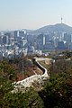 View of the Downtown Seoul and N Seoul Tower behind the Seoul City Wall
 -
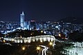 A night view from Naksan Mountain
 -
 A snowy view of Fortress Wall of Seoul
 -
 Sungnyemun Gate, Seoul
 -
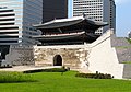
 Hanyangdoseong, which shows restoration efforts made by the Seoul government
 -
 Hanyangdoseong at Seoul City Wall Park and Naksan Park, Seoul

_2011%EB%85%84_11%EC%9B%94_%EB%8C%80%ED%95%9C%EB%AF%BC%EA%B5%AD_%EC%84%9C%EC%9A%B8%ED%8A%B9%EB%B3%84%EC%8B%9C_%EB%AA%85%EC%86%8C_(Seoul_best_attractions)_%EC%82%AC%EB%B3%B8_-%EB%82%99%EC%82%B0%EC%95%BC%EA%B2%BD1-1.jpg)


.jpg)
.jpg)
See also[edit]
Notes and References[edit]
- ^ 김, 기호; 김, 웅호; 염, 복규; 김, 영심; 김, 도연; 유, 승희; 박, 준형 (2021-11-30). 서울도시계획사 1 현대 이전의 도시계획 (서울역사총서 12) [History of urban planning in Seoul, Vol. 1., Urban planning before contemporary age] (in Korean). Seoul: Seoul Historiography Institute. ISBN 9791160711301.
- ^ Song, In Ho; Kim, Young Soo; Moon, In Sik (August 2021). "Repair and Construction Methods of Hanyangdoseong in 18th Century". Korean Association of Architectural History (in Korean). 30 (4): 79–90. doi:10.7738/JAH.2021.30.4.079. Retrieved 2024-03-06.
- ^ 김, 경록; 유, 승희; 김, 경태; 이, 현진; 정, 은주; 최, 진아; 이, 민우; 진, 윤정 (2019-06-03). 조선시대 다스림으로 본 성저십리 (서울역사중점연구 5) [Seongjeosimni in governance of Joseon (Studies on special topics of Seoul History, Vol. 5.)] (in Korean). Seoul: Seoul Historiography Institute. ISBN 9791160710670.
- ^ Kim, Young Soo; Song, In Ho (April 2021). "Form and Location of Chiseong(square-shaped lookout) Constructed in Hanyangdoseong(Seoul city wall) of the 18th Century". Korean Association of Architectural History (in Korean). 30 (2): 19–28. doi:10.7738/JAH.2021.30.2.019. Retrieved 2024-03-06.
- ^ Lee, Myeong Seong; Kim, Yuri; Choie, Myoungju; Yoo, Ji Hyun; Ahn, Yu Bin (February 2020). "Material and Deterioration Characteristic Analysis for Inscribed Stones of Naksan Mountain Area of the Hanyangdoseong(Seoul City Wall), Korea". Journal of Conservation Science. 36 (1): 60–72. doi:10.12654/JCS.2020.36.1.06. Retrieved 2024-03-06.
- ^ McKechnie, Ben (2024-02-01). "Discover Seoul's five best hiking trails with an expert guide". BBC Travel. Seoul.
- ^ a b UNESCO (2014-08-15). "Seoul City Wall". UNESCO. UNESCO.
- ^ Discovering Korea (2014-07-30). "Hiking Hanyangdoseong". Discovering Korea. Discovering Korea. Archived from the original on 2014-08-10.
- ^ Visit Korea (2014-07-30). "Hiking trip along the Wall". Visit Korea. Visit Korea. Archived from the original on 2014-08-06. Retrieved 2014-07-30.
- ^ "Hanyangdoseong: Excursions Along the Wall". Retrieved 2020-07-01.
External links[edit]
- Official website of Seoul City Wall by Seoul Metropolitan Government (available in English)
- Official website of Cultural Heritage Administration on Hanyangdoseong (in English)
| ||
| Authority control databases: National |
|---|