File:WillametteRvrPano edit.jpg
 From Wikipedia the free encyclopedia

Size of this preview: 798 × 124 pixels. Other resolutions: 320 × 50 pixels | 640 × 100 pixels | 1,024 × 159 pixels | 1,280 × 199 pixels | 7,073 × 1,100 pixels.
Original file (7,073 × 1,100 pixels, file size: 2.87 MB, MIME type: image/jpeg)
| This is a file from the Wikimedia Commons. Information from its description page there is shown below. Commons is a freely licensed media file repository. You can help. |
| This is a featured picture, which means that members of the community have identified it as one of the finest images on the English Wikipedia, adding significantly to its accompanying article. If you have a different image of similar quality, be sure to upload it using the proper free license tag, add it to a relevant article, and nominate it. |
| This image was selected as picture of the day on the English Wikipedia for November 28, 2007. |
|
Summary
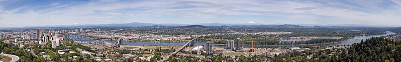
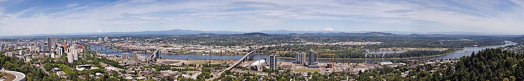
| Description | The Willamette River as it passes through downtown Portland, Oregon. This image is a stitch made from 10 photographs. The bridges, from right to left, are the Sellwood, Ross Island, Marquam, Hawthorne, Morrison, Burnside, Steel (the black bridge that is partially obscured), Fremont (the arch bridge at far left). The mountains, from right to left, are Mount Hood, Mount Adams (only the tip is visible) and Mount Saint Helens. | ||
| Date | |||
| Source |
| ||
| Author | Cacophony |
| Camera location | | View this and other nearby images on: OpenStreetMap |
|---|
Licensing
I, Cacophony, the copyright holder of this work, hereby publishes it under the following licenses:
 | Permission is granted to copy, distribute and/or modify this document under the terms of the GNU Free Documentation License, Version 1.2 or any later version published by the Free Software Foundation; with no Invariant Sections, no Front-Cover Texts, and no Back-Cover Texts. A copy of the license is included in the section entitled GNU Free Documentation License. |
| This file is licensed under the Creative Commons Attribution-Share Alike 3.0 Unported license. | ||
| Attribution: I, Cacophony | ||
| ||
| This licensing tag was added to this file as part of the GFDL licensing update. |
This file is licensed under the Creative Commons Attribution-Share Alike 2.5 Generic, 2.0 Generic and 1.0 Generic license.
Attribution: I, Cacophony
- You are free:
- to share – to copy, distribute and transmit the work
- to remix – to adapt the work
- Under the following conditions:
- attribution – You must give appropriate credit, provide a link to the license, and indicate if changes were made. You may do so in any reasonable manner, but not in any way that suggests the licensor endorses you or your use.
- share alike – If you remix, transform, or build upon the material, you must distribute your contributions under the same or compatible license as the original.
You may select the license of your choice.
File history
Click on a date/time to view the file as it appeared at that time.
| Date/Time | Thumbnail | Dimensions | User | Comment | |
|---|---|---|---|---|---|
| current | 02:26, 1 July 2007 | 7,073 × 1,100 (2.87 MB) | Fir0002 | == Summary == {{Information |Description=The Willamette River as it passes through downtown Portland, Oregon. This image is a stitch made from 10 photographs. The bridges, from right to left, are the Sellwood, Ross Island, Marquam, Hawthorne, Morrision, |
File usage
The following pages on the English Wikipedia use this file (pages on other projects are not listed):
- Boring Lava Field
- List of longest streams of Oregon
- Panoramic photography
- Portland, Oregon
- User:Another Believer/Travel/United States
- User talk:Cacophony/Archive3
- Wikipedia:Featured picture candidates/July-2007
- Wikipedia:Featured picture candidates/Willamette River in Portland
- Wikipedia:Featured pictures/Places/Panorama
- Wikipedia:Featured pictures thumbs/07
- Wikipedia:Picture of the day/November 2007
- Wikipedia:WikiProject Oregon/Featured
- Wikipedia:Wikipedia Signpost/2007-07-16/Features and admins
- Wikipedia:Wikipedia Signpost/2007-07-16/SPV
- Wikipedia:Wikipedia Signpost/Single/2007-07-16
- Template:POTD/2007-11-28
- Portal:Oregon
- Portal:Oregon/Featured content
- Portal:Oregon/Selected panorama
- Portal:Oregon/Selected panorama/1
- Portal:United States/Selected panorama
- Portal:United States/Selected panorama/15
Global file usage
The following other wikis use this file:
- Usage on br.wikipedia.org
- Usage on eo.wikipedia.org
- Usage on es.wikipedia.org
- Usage on fr.wikipedia.org
- Usage on fy.wikipedia.org
- Usage on gu.wikipedia.org
- Usage on hi.wikipedia.org
- Usage on hu.wikipedia.org
- Usage on ja.wikipedia.org
- Usage on kn.wikipedia.org
- Usage on ms.wikipedia.org
- Usage on pl.wikipedia.org
- Usage on pt.wikipedia.org
- Usage on ru.wikipedia.org
- Usage on so.wikipedia.org
- Usage on ta.wikipedia.org
- Usage on tr.wikipedia.org
- Usage on uk.wikipedia.org
- Usage on ur.wikipedia.org
- Usage on vi.wikipedia.org
- Usage on yo.wikipedia.org
- Usage on zh.wikipedia.org