File:VietnameseProvincesMap.png
 From Wikipedia the free encyclopedia
Size of this preview: 360 × 600 pixels. Other resolutions: 144 × 240 pixels | 428 × 713 pixels.
Original file (428 × 713 pixels, file size: 29 KB, MIME type: image/png)
| This is a file from the Wikimedia Commons. Information from its description page there is shown below. Commons is a freely licensed media file repository. You can help. |
 | This locator map image could be re-created using vector graphics as an SVG file. This has several advantages; see Commons:Media for cleanup for more information. If an SVG form of this image is available, please upload it and afterwards replace this template with {{vector version available|new image name}}. It is recommended to name the SVG file “VietnameseProvincesMap.svg”—then the template Vector version available (or Vva) does not need the new image name parameter. |
Original at: w:Image:VietnameseProvincesMap.png, where it says:
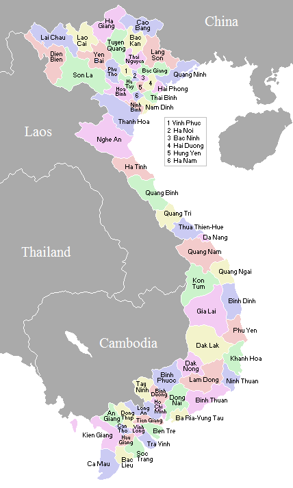
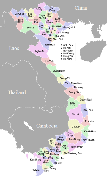
A map showing the borders and names of the Vietnamese provinces (including the changes approved in Nov 2003)
This country locator map was created by Vardion and is released into the public domain.
So this map is up to date as per current situation Waerth 07:19, 17 Mar 2005 (UTC)
See vi:Image:VietnameseProvincesMapTiengViet.png for the same map with the correctly accented Vietnamese names.
Waerth, the copyright holder of this work, hereby publishes it under the following license:
| I, the copyright holder of this work, release this work into the public domain. This applies worldwide. In some countries this may not be legally possible; if so: I grant anyone the right to use this work for any purpose, without any conditions, unless such conditions are required by law. |
en:Image:VietnameseProvincesMap.png
File history
Click on a date/time to view the file as it appeared at that time.
| Date/Time | Thumbnail | Dimensions | User | Comment | |
|---|---|---|---|---|---|
| current | 02:56, 2 November 2007 | | 428 × 713 (29 KB) | Vietlong | Reverted to version as of 11:41, 30 August 2006 |
| 11:47, 30 August 2006 |  | 428 × 713 (25 KB) | Vietlong | Reverted to earlier revision | |
| 11:41, 30 August 2006 |  | 428 × 713 (29 KB) | Vietlong | Correcting the boundary between Lai Chau and Lao Cai provinces | |
| 21:58, 20 January 2006 |  | 428 × 713 (25 KB) | Vardion | correcting boundary between Dien Bien and Lai Chau provinces | |
| 05:55, 18 April 2005 |  | 428 × 713 (25 KB) | Vardion | fixing error | |
| 07:17, 17 March 2005 |  | 428 × 713 (25 KB) | Waerth | {{PD}} |
File usage
The following pages on the English Wikipedia use this file (pages on other projects are not listed):
Global file usage
The following other wikis use this file:
- Usage on ace.wikipedia.org
- Usage on ar.wikipedia.org
- Usage on ba.wikipedia.org
- Usage on bg.wiktionary.org
- Usage on blk.wikipedia.org
- Usage on bn.wikipedia.org
- Usage on ca.wikipedia.org
- Usage on ce.wikipedia.org
- Usage on da.wikipedia.org
- Usage on fi.wikipedia.org
- Usage on gl.wikipedia.org
- Usage on id.wikipedia.org
- Usage on it.wikipedia.org
- Usage on kk.wikipedia.org
- Usage on krc.wikipedia.org
- Usage on kv.wikipedia.org
- Usage on lt.wikipedia.org
- Usage on lv.wikipedia.org
- Usage on map-bms.wikipedia.org
- Usage on ms.wikipedia.org
- Usage on my.wikipedia.org
- Usage on nl.wikipedia.org
- Usage on no.wikipedia.org
- Usage on os.wikipedia.org
- Usage on pam.wikipedia.org
- Usage on pl.wikipedia.org
- Usage on pt.wikipedia.org
- Usage on roa-tara.wikipedia.org
- Usage on ru.wikipedia.org
- Usage on su.wikipedia.org
- Usage on sv.wikipedia.org
- Usage on tr.wikipedia.org
View more global usage of this file.