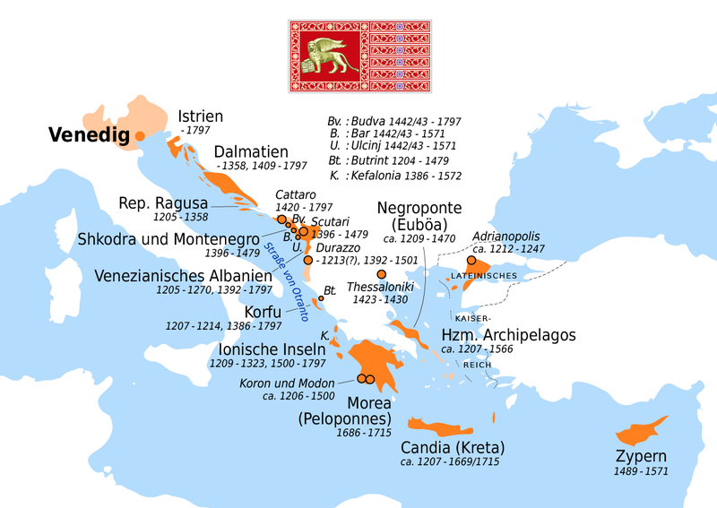
File:Venezianische Kolonien.png
 From Wikipedia the free encyclopedia

Size of this preview: 800 × 567 pixels. Other resolutions: 320 × 227 pixels | 640 × 454 pixels | 1,024 × 726 pixels | 1,189 × 843 pixels.
Original file (1,189 × 843 pixels, file size: 161 KB, MIME type: image/png)
| This is a file from the Wikimedia Commons. Information from its description page there is shown below. Commons is a freely licensed media file repository. You can help. |

![[4]](https://upload.wikimedia.org/wikipedia/commons/archive/3/39/20210927042257%21Venezianische_Kolonien.png)
| Description |
| |
| Date | ||
| Source | Self made, using and the following sources:
| |
| Author | Maximilian Dörrbecker (Chumwa) | |
| Permission (Reusing this file) | I, the copyright holder of this work, hereby publish it under the following license: This file is licensed under the Creative Commons Attribution-Share Alike 2.5 Generic license.
Sie dürfen das Bild zu den folgenden Bedingungen nutzen:
|
File history
Click on a date/time to view the file as it appeared at that time.
| Date/Time | Thumbnail | Dimensions | User | Comment | |
|---|---|---|---|---|---|
| current | 04:22, 27 September 2021 | | 1,189 × 843 (161 KB) | GPinkerton | Reverted to version as of 14:03, 23 December 2016 (UTC) COM:CROP |
| 19:12, 18 August 2020 |  | 1,189 × 843 (186 KB) | Claude Zygiel | Added "Dogado", "Domini di Terraferma" & "Stato da Màr" | |
| 09:43, 18 August 2020 |  | 1,189 × 843 (178 KB) | Claude Zygiel | Distinguished cities, territories and influence areas | |
| 14:03, 23 December 2016 |  | 1,189 × 843 (161 KB) | Chumwa | diverse Korrekturen und Ergänzungen | |
| 15:13, 10 November 2016 |  | 1,206 × 796 (145 KB) | Chumwa | Shkodra und Montenegro hinzugefügt | |
| 23:53, 24 October 2014 |  | 1,206 × 796 (92 KB) | Kopiersperre | optipng | |
| 09:20, 6 June 2009 |  | 1,206 × 796 (141 KB) | Chumwa | höhere Auflösung | |
| 09:15, 6 June 2009 |  | 804 × 531 (83 KB) | Chumwa | weitere Anmerkungen von Hans-Jürgen Hübner eingearbeitet | |
| 22:21, 31 May 2009 |  | 804 × 531 (84 KB) | Chumwa | Anmerkungen von Hans-Jürgen Hübnereingearbeitet: Ich fange einfach mal links oben an, wo „Direkte Einflussgebiete in der Lombardei steht“. Das dort eingezeichnete Gebiet war zu dieser Zeit (1797 wohl, jedenfal | |
| 05:49, 29 May 2009 |  | 804 × 531 (77 KB) | Chumwa | Auf Wunsch von Hans-Jürgen Hübner "Direkte Einflussgebiete in der Lombardei“ durch „Direkte Einflussgebiete in Oberitalien“ ersetzt. |
File usage
The following pages on the English Wikipedia use this file (pages on other projects are not listed):
- Argos, Peloponnese
- Commercial revolution
- Duchy of Durazzo (Republic of Venice)
- Duchy of the Archipelago
- Fourth Crusade
- Frankokratia
- Italian city-states
- Kingdom of Candia
- Kingdom of the Morea
- Koroni
- Methoni, Messenia
- Monemvasia
- Mykonos
- Nafplio
- Parga
- Poros
- Pylos
- Republic of Venice
- Siege of Famagusta
- Siege of Thessalonica (1422–1430)
- Skyros
- Stato da Màr
- Triarchy of Negroponte
- Venetian Albania
- Venetian Cyprus
- Venetian Dalmatia
- Venetian Works of Defence between the 16th and 17th centuries: Stato da Terra – Western Stato da Mar
- Venetian rule in the Ionian Islands
- User:Falcaorib
- User:Kazkaskazkasako/Books/History
- Template:Stato da Mar
Global file usage
The following other wikis use this file:
- Usage on ar.wikipedia.org
- Usage on arz.wikipedia.org
- Usage on ast.wikipedia.org
- Usage on be.wikipedia.org
- Usage on ca.wikipedia.org
- Usage on cs.wikipedia.org
- Usage on cy.wikipedia.org
- Usage on da.wikipedia.org
- Usage on de.wikipedia.org
- Geschichte Italiens
- Republik Venedig
- Arbëresh
- Venedig
- Andrea Dandolo
- Šolta
- Benutzer:Chumwa
- Venezianische Kolonien
- Seerepubliken
- Wikipedia:Kartenwerkstatt/Archiv/2008-05
- Benutzer Diskussion:Chumwa/Archiv/2009/1. Quartal
- Benutzer:KaterBegemot/Kartografen
- Wikipedia Diskussion:Hauptseite/Artikel des Tages/Archiv/Vorschläge/2012/1
- Wikipedia:Auskunft/Archiv/2013/Woche 49
- Wikipedia:Hauptseite/Archiv/4. April 2012
- Wikipedia:Kartenwerkstatt/Karte des Tages/Galerie
- Schweizer Truppen in venezianischen Diensten
- Benutzer:Chumwa/SomeOfMyFiles
- Fürstentum Albanien (1368–1392)
- Benutzer Diskussion:Chumwa/Archiv/2016/4. Quartal
- Usage on de.wikivoyage.org
- Usage on el.wikipedia.org
- Usage on es.wikipedia.org
- Usage on et.wikipedia.org
- Usage on fa.wikipedia.org
- Usage on fr.wikipedia.org
- Usage on ga.wikipedia.org
- Usage on gl.wikipedia.org
- Usage on he.wikipedia.org
- Usage on hr.wikipedia.org
View more global usage of this file.