File:Vegetation-no-legend.PNG
 From Wikipedia the free encyclopedia

Size of this preview: 800 × 359 pixels. Other resolutions: 320 × 144 pixels | 640 × 287 pixels | 1,385 × 622 pixels.
Original file (1,385 × 622 pixels, file size: 61 KB, MIME type: image/png)
| This is a file from the Wikimedia Commons. Information from its description page there is shown below. Commons is a freely licensed media file repository. You can help. |
Summary
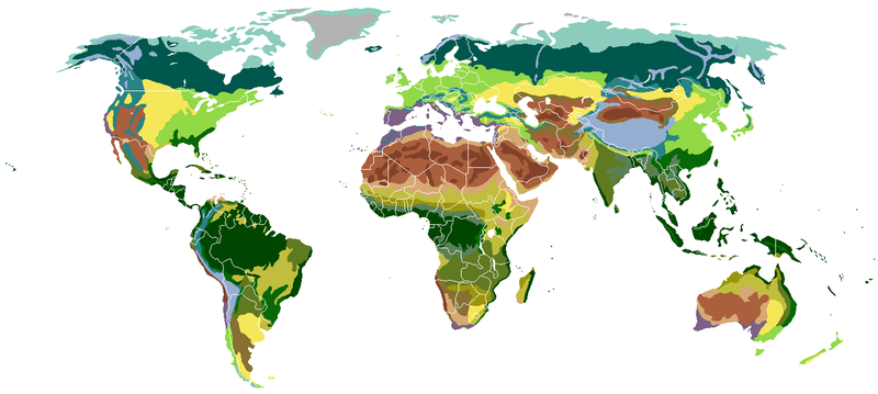
| Description | English: The main biomes in the world. Ice sheet and polar desert Tundra Taiga Temperate broadleaf and mixed forest Temperate steppe Subtropical moist forest Mediterranean vegetation Tropical and subtropical moist broadleaf forests Arid desert Xeric shrubland Dry steppe Semiarid desert Grass savanna Tree savanna Tropical and subtropical dry forest Tropical rainforest Alpine tundra Montane forest Italiano: I principali biomi nel mondo. Coltre di ghiaccio e deserto polare Tundra artica Taiga Foresta temperata di latifoglie e mista Steppa temperata Foresta umida subtropicale Vegetazione Mediterranea Foresta umida di latifoglie tropicale e subtropicale Deserto arido Deserto e macchia xerofila Steppa arida Deserto semiarido Savana erbosa Savana arborea Foresta monsonica Foresta pluviale tropicale Tundra alpina Foresta montana Español: The main biomes in the world. Capa de hielo y desierto polar Tundra Taiga Bosques templados de frondosas y mixtos Estepa templada Bosques humedos subtropical Vegetación mediterranea Bosque húmedo tropical y subtropical de frondosas Desierto árido Matorral xerófilo Estepa seca Desierto semiárido Sabana de hierba Tree savanna Bosque seco tropical Selva tropical Pradera alpina Bosque de montaña 中文:世界陆地自然区域分布。 冰盖及极地荒漠 苔原 针叶林 温带阔叶林 温带草原 亚热带雨林 地中海硬叶林 季雨林 沙漠 近沙漠 干旱草原 半干旱沙漠 稀树草原 多树草原 亚热带干燥林 热带雨林 高山苔原 山地森林 Polski: Główne biomy występujące na Ziemi. pokrywy lodowe i pustynie polarne tundra tajga las liściasty strefy umiarkowanej stepy podzwrotnikowy las tropikalny roślinność śródziemnomorska lasy monsunowe pustynie jałowe sucha roślinność suche stepy pustynie półsuche sawanna trawiasta sawanna drzewiasta las podzwrotnikowy suchy lasy tropikalne tundra alpejska lasy górskie Français : Les principaux biomes du monde. Inlandsis et déserts polaires Toundra Taïga Forêts feuillues caducifoliées tempérées Prairies Forêts sempervirentes subtropicales Forêts sempervirentes méditerranéennes Forêts de mousson Déserts arides Déserts et broussailles xérophytes Steppe aride Déserts semi-arides Savanes Savanes et forêts claires Forêts tropicales caducifoliées Forêts sempervirentes tropicales Toundra alpine Forêts de montagne Русский: Карта распределения основных биомов суши. Арктическая пустыня Тундра Тайга Смешанный лес Лесостепь Субтропический лес Жестколистные вечнозеленые леса и кустарники Муссонный лес Засушливая пустыня Полупустыня Засушливая степь Полузасушливая пустыня Травянистая саванна Древесная саванна Сухие тропические леса Влажные тропические леса Альпийская тундра Горный лес Українська: Основні біоми Землі. Льодовики та Полярні пустелі Тундра Тайга Листопадні ліси помірного клімату Степи Субтропічні дощові ліси Чапараль Мусонні ліси Пустелі Скреб Сухі степи Напівпустелі Савани Лісостеп Субтропічний сухий ліс Тропічний дощовий ліс Альпійські луки Гірські криволісся |
| Date | |
| Source | Image:Vegetation.png |
| Author | Sten Porse |
| Other versions | Derivative works of this file: Africa vegetation.png Image:Kasvillisuus.png Image:Vegetation.png |
 | This biogeographical map image could be re-created using vector graphics as an SVG file. This has several advantages; see Commons:Media for cleanup for more information. If an SVG form of this image is available, please upload it and afterwards replace this template with {{vector version available|new image name}}. It is recommended to name the SVG file “Vegetation-no-legend.svg”—then the template Vector version available (or Vva) does not need the new image name parameter. |
Licensing
I, the copyright holder of this work, hereby publish it under the following licenses:
 | Permission is granted to copy, distribute and/or modify this document under the terms of the GNU Free Documentation License, Version 1.2 or any later version published by the Free Software Foundation; with no Invariant Sections, no Front-Cover Texts, and no Back-Cover Texts. A copy of the license is included in the section entitled GNU Free Documentation License. |
| This file is licensed under the Creative Commons Attribution-Share Alike 3.0 Unported license. | ||
| ||
| This licensing tag was added to this file as part of the GFDL licensing update. |
This file is licensed under the Creative Commons Attribution-Share Alike 2.5 Generic, 2.0 Generic and 1.0 Generic license.
- You are free:
- to share – to copy, distribute and transmit the work
- to remix – to adapt the work
- Under the following conditions:
- attribution – You must give appropriate credit, provide a link to the license, and indicate if changes were made. You may do so in any reasonable manner, but not in any way that suggests the licensor endorses you or your use.
- share alike – If you remix, transform, or build upon the material, you must distribute your contributions under the same or compatible license as the original.
You may select the license of your choice.
File history
Click on a date/time to view the file as it appeared at that time.
| Date/Time | Thumbnail | Dimensions | User | Comment | |
|---|---|---|---|---|---|
| current | 03:48, 15 June 2020 | | 1,385 × 622 (61 KB) | Berkserker | New version with corrections to match the file with a legend |
| 01:34, 25 August 2017 |  | 1,385 × 622 (74 KB) | SirHenrry | Uploaded | |
| 20:38, 11 May 2017 |  | 1,385 × 622 (74 KB) | SirHenrry | Update Biomes | |
| 03:13, 24 June 2016 |  | 1,385 × 622 (74 KB) | SirHenrry | Corregido error en el tipo de ecosistema, Venezuela-Colombia, cambiado de Árido a Semiarido | |
| 03:08, 24 June 2016 |  | 1,385 × 622 (74 KB) | SirHenrry | Colombia and Venezuela Updates Biomes. | |
| 17:32, 27 November 2013 |  | 1,385 × 622 (59 KB) | Abrahamic Faiths | Resize to Remove unnecessary white spaces. | |
| 19:59, 29 November 2012 |  | 1,425 × 753 (83 KB) | Altaileopard | Venezuela mountain steppe according to Diercke Weltatlas | |
| 19:57, 3 October 2012 |  | 1,425 × 753 (83 KB) | Altaileopard | corrections accoring to Diercke Weltatlas (see: http://www.diercke.de/) (subtropical) dry forests in Africa and India are more extended | |
| 02:57, 9 July 2011 |  | 1,425 × 753 (75 KB) | Maphobbyist | South Sudan has become independent on July 9, 2011. Sudan and South Sudan are shown with the new international border between them. | |
| 20:21, 6 July 2011 |  | 1,425 × 753 (3.08 MB) | Thiridaz | More corrections |
File usage
The following pages on the English Wikipedia use this file (pages on other projects are not listed):
- Eurasian Steppe
- Global 200
- History of botany
- List of ecoregions in Bulgaria
- Outline of forestry
- Vegetation
- Talk:Celtic rainforests in Wales
- Talk:Great Sand Sea
- Talk:María Gloria Domínguez-Bello
- Talk:Peatland restoration
- Talk:Rincon (meadow)
- Talk:San Lorenzo (Córdoba, Argentina)
- Talk:Seasonal semideciduous forest
- Talk:Sustainability/Measuring sustainability/Archive 1
- Talk:Urchin barren
- Talk:Woodland and scrub communities in the British National Vegetation Classification system
- User:D4g0thur/Biomes
- User:Derpythorki
- User:Eliezg/Sandbox
- User:Every-leaf-that-trembles
- User:Irtapil/Interesting Projects
- User:MiseDominic
- User:NittyG/test
- User:Steeltree1/sandbox
- User:Tuanminh01/Template18
- User talk:Altaileopard
- User talk:GreekDemiGods/sandbox
- Wikipedia:Reference desk/Archives/Science/2008 July 9
- Wikipedia:Userboxes/WikiProjects/Environment
- Wikipedia:Userboxes/WikiProjects/Life Science
- Wikipedia:Userboxes/WikiProjects/alphabetical/10
- Template:User WikiProject Ecoregions
- Template:WikiProject Biomes
- Template:WikiProject banner shell/mockup3
- Template talk:WP Biomes
- Template talk:WikiProject Biomes
- Template talk:WikiProject banner shell/Archive 8
- Category talk:Southern Rift montane forest–grassland mosaic
- Portal:Ecology/Selected article
- Portal:Ecology/Selected article/19
- Draft talk:Emmanuelismo
- Draft talk:Goris District
- Draft talk:Natural Temperate Grassland of the Victorian Volcanic Plain
- Draft talk:Schulz Bank
Global file usage
The following other wikis use this file:
- Usage on af.wikipedia.org
- Usage on anp.wikipedia.org
- Usage on ar.wikipedia.org
- Usage on ar.wikiversity.org
- Usage on ast.wikipedia.org
- Usage on as.wikipedia.org
- Usage on az.wikipedia.org
- Usage on ba.wikipedia.org
- Usage on be-tarask.wikipedia.org
- Usage on be.wikipedia.org
- Usage on bg.wikipedia.org
View more global usage of this file.