File:Triple Occupation of Greece.png
 From Wikipedia the free encyclopedia

Size of this preview: 588 × 600 pixels. Other resolutions: 235 × 240 pixels | 471 × 480 pixels | 899 × 917 pixels.
Original file (899 × 917 pixels, file size: 186 KB, MIME type: image/png)
| This is a file from the Wikimedia Commons. Information from its description page there is shown below. Commons is a freely licensed media file repository. You can help. |
Summary
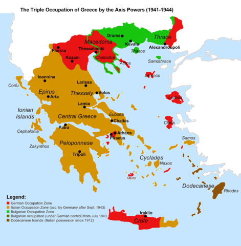
| Description | English: Map of the 1941-1944 Axis Occupation of Greece. Depicted are the three occupation zones, plus the geographic regions and major urban centres. |
| Date | |
| Source | Own work based on: Gr-triple-occupation.png, with minor corrections in the territorial extent of the occupation zones, and added information. References:
|
| Author | Cplakidas |
| Other versions | []
|


_-fr.png)


Licensing
 | Permission is granted to copy, distribute and/or modify this document under the terms of the GNU Free Documentation License, Version 1.2 or any later version published by the Free Software Foundation; with no Invariant Sections, no Front-Cover Texts, and no Back-Cover Texts. A copy of the license is included in the section entitled GNU Free Documentation License. |
| This file is licensed under the Creative Commons Attribution-Share Alike 3.0 Unported license. | ||
| ||
| This licensing tag was added to this file as part of the GFDL licensing update. |
File history
Click on a date/time to view the file as it appeared at that time.
| Date/Time | Thumbnail | Dimensions | User | Comment | |
|---|---|---|---|---|---|
| current | 15:52, 6 June 2021 | | 899 × 917 (186 KB) | Hohum | Avoiding blue for land areas |
| 22:10, 19 June 2014 |  | 899 × 917 (161 KB) | Hohum | Better regional context | |
| 20:10, 19 January 2009 |  | 899 × 917 (112 KB) | Cplakidas | correct Melos | |
| 01:47, 24 September 2008 |  | 899 × 917 (113 KB) | Cplakidas | ||
| 00:08, 25 March 2008 |  | 899 × 917 (113 KB) | Cplakidas | Corrected Evros prefecture (wholly German-occupied) | |
| 14:29, 20 March 2008 |  | 899 × 917 (113 KB) | Cplakidas | {{Information |Description={{en|Map of the 1941-1944 Axis Occupation of Greece. Depicted are the three occupation zones, plus the geographic regions and major urban centres.}} |Source=Image based on [http://commons.wikimedia.org/wiki/Image:Gr-triple-occup |
File usage
The following pages on the English Wikipedia use this file (pages on other projects are not listed):
- Axis occupation of Greece
- Battle of Crete
- Drama uprising
- German invasion of Greece
- Great Famine (Greece)
- Greco–Italian War
- Greek resistance
- History of modern Greece
- History of modern Macedonia (Greece)
- History of the Cyclades
- History of the Jews in Thessaloniki
- History of the Kingdom of Italy (1861–1946)
- Kingdom of Greece
- Military history of Greece during World War II
- Military history of Italy during World War II
- Ohrana
- Political Committee of National Liberation
- Slavic speakers of Greek Macedonia
- The Holocaust in Greece
Global file usage
The following other wikis use this file:
- Usage on ar.wikipedia.org
- Usage on azb.wikipedia.org
- Usage on az.wikipedia.org
- Usage on ba.wikipedia.org
- Usage on be.wikipedia.org
- Usage on bg.wikipedia.org
- Usage on cs.wikipedia.org
- Usage on da.wikipedia.org
- Usage on de.wikipedia.org
- Usage on el.wikipedia.org
- Usage on es.wikipedia.org
- Usage on fa.wikipedia.org
- Usage on fr.wikipedia.org
- Usage on gl.wikipedia.org
- Usage on hu.wikipedia.org
- Usage on hy.wikipedia.org
- Usage on id.wikipedia.org
- Usage on io.wikipedia.org
- Usage on it.wikipedia.org
- Usage on ja.wikipedia.org
- Usage on ka.wikipedia.org
- Usage on ko.wikipedia.org
- Usage on lv.wikipedia.org
- Usage on mk.wikipedia.org
- Usage on ms.wikipedia.org
- Usage on nl.wikipedia.org
- Usage on nn.wikipedia.org
- Usage on no.wikipedia.org
View more global usage of this file.