File:Southwark Civil Parish Map 1870.png
 From Wikipedia the free encyclopedia

Size of this preview: 697 × 600 pixels. Other resolutions: 279 × 240 pixels | 558 × 480 pixels | 893 × 768 pixels | 1,190 × 1,024 pixels | 2,380 × 2,048 pixels | 7,982 × 6,869 pixels.
Original file (7,982 × 6,869 pixels, file size: 2.63 MB, MIME type: image/png)
| This is a file from the Wikimedia Commons. Information from its description page there is shown below. Commons is a freely licensed media file repository. You can help. |
Summary
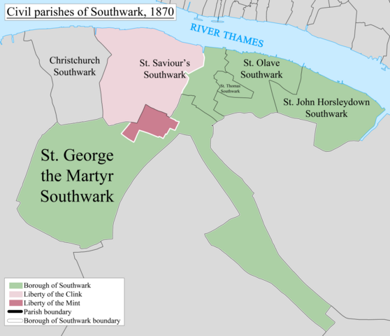
| Description | English: A map showing the civil parishes of Southwark as they appeared in 1870. Based on the Ordnance Survey Town Plan of London (1871-76) at 1:1056 scale. |
| Date | 21 February 2014, 10:47:22 AM |
| Source | Own work |
| Author | Doc77can |
Licensing
I, the copyright holder of this work, hereby publish it under the following license:
This file is licensed under the Creative Commons Attribution-Share Alike 3.0 Unported license.
- You are free:
- to share – to copy, distribute and transmit the work
- to remix – to adapt the work
- Under the following conditions:
- attribution – You must give appropriate credit, provide a link to the license, and indicate if changes were made. You may do so in any reasonable manner, but not in any way that suggests the licensor endorses you or your use.
- share alike – If you remix, transform, or build upon the material, you must distribute your contributions under the same or compatible license as the original.
File history
Click on a date/time to view the file as it appeared at that time.
| Date/Time | Thumbnail | Dimensions | User | Comment | |
|---|---|---|---|---|---|
| current | 13:37, 21 February 2014 | | 7,982 × 6,869 (2.63 MB) | Doc77can | User created page with UploadWizard |
File usage
The following pages on the English Wikipedia use this file (pages on other projects are not listed):
- Liberty of the Clink
- Liberty of the Mint
- List of civil parishes in the City of London
- Southwark
- Southwark Christchurch
- Southwark St George the Martyr
- Southwark St John Horsleydown
- Southwark St Olave
- Southwark St Saviour
- St Olave District (Metropolis)
- St Saviour's District (Metropolis)
- St Thomas' Hospital
- User:Doc77can
Global file usage
The following other wikis use this file:
- Usage on de.wikipedia.org
- Usage on it.wikipedia.org