File:Siege of Homs Map.svg
 From Wikipedia the free encyclopedia

Size of this PNG preview of this SVG file: 588 × 599 pixels. Other resolutions: 235 × 240 pixels | 471 × 480 pixels | 753 × 768 pixels | 1,005 × 1,024 pixels | 2,009 × 2,048 pixels | 883 × 900 pixels.
Original file (SVG file, nominally 883 × 900 pixels, file size: 4.91 MB)
| This is a file from the Wikimedia Commons. Information from its description page there is shown below. Commons is a freely licensed media file repository. You can help. |
Summary
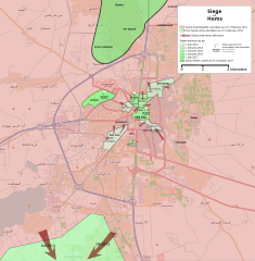
| Description | English: Map showing the current strategic situation in Homs as of January 2014. Red represents area under Government control. Green represents Opposition control. | ||||
| Date | |||||
| Source | Own work | ||||
| Author | MrPenguin20 | ||||
| Other versions |
|


.svg)

.png)


.svg)


.svg)


_Territory_Change_2014-2016.gif)

_(within_Northern_Syria).svg)


.png)
.svg)


_map.png)
.svg)


.svg)


Licensing
| This work contains information from OpenStreetMap, which is made available under the Open Database License (ODbL). The ODbL does not require any particular license for maps produced from ODbL data. Prior to 1 August 2020, map tiles produced by the OpenStreetMap Foundation were licensed under the CC-BY-SA-2.0 license. Maps produced by other people may be subject to other licences. |
I, the copyright holder of this work, hereby publish it under the following license:
This file is licensed under the Creative Commons Attribution-Share Alike 3.0 Unported license.
- You are free:
- to share – to copy, distribute and transmit the work
- to remix – to adapt the work
- Under the following conditions:
- attribution – You must give appropriate credit, provide a link to the license, and indicate if changes were made. You may do so in any reasonable manner, but not in any way that suggests the licensor endorses you or your use.
- share alike – If you remix, transform, or build upon the material, you must distribute your contributions under the same or compatible license as the original.
File history
Click on a date/time to view the file as it appeared at that time.
| Date/Time | Thumbnail | Dimensions | User | Comment | |
|---|---|---|---|---|---|
| current | 19:35, 3 August 2018 | | 883 × 900 (4.91 MB) | Rr016 | Correction: rebels did not control that much north of Homs |
| 20:36, 10 December 2017 |  | 883 × 900 (4.92 MB) | Kami888 | Made several changes to improve presentation, ask on talk page if any questions. | |
| 17:28, 9 October 2017 |  | 883 × 900 (4.82 MB) | Rr016 | Fixes: added Shamas district, labeled more districts, fixed date of SAA offensive south of Homs, adjusted Bayada frontlines. | |
| 18:07, 8 October 2017 |  | 883 × 900 (4.82 MB) | Rr016 | Major overhaul, inspired by Kami88's Battle of Qalamoun.svg layout. Map now shows all territory lost by opposition from 2012 - 2017. Used https://www.facebook.com/the.arab.chronicle/photos/a.454685571308535.1073741828.453010751476017/524550737655351/?t... | |
| 01:14, 11 May 2014 |  | 883 × 900 (4.77 MB) | MrPenguin20 | Updated map to show current areas of control (will update further to show progression of siege). | |
| 23:02, 20 April 2014 |  | 883 × 900 (4.77 MB) | MrPenguin20 | Update following recent offensives. | |
| 21:14, 8 April 2014 |  | 883 × 900 (4.77 MB) | MrPenguin20 | Changed Dar al-Kabirah to contested. | |
| 22:53, 13 February 2014 |  | 883 × 900 (4.77 MB) | MrPenguin20 | Updated map in line with https://pbs.twimg.com/media/BgWebW3CcAAJLbS.jpg:large | |
| 15:35, 4 February 2014 |  | 883 × 900 (4.77 MB) | MrPenguin20 | Removed "Homs" from center of map. Reworked frontlines in line with map visible at http://online.wsj.com/news/articles/SB10001424052702303277704579346833918268994?mg=reno64-wsj&url=http%3A%2F%2Fonline.wsj.com%2Farticle%2FSB10001424052702303277704579346... | |
| 19:09, 30 January 2014 |  | 883 × 900 (4.77 MB) | MrPenguin20 | Expanded area of opposition control north of Homs. |
File usage
The following pages on the English Wikipedia use this file (pages on other projects are not listed):
Global file usage
The following other wikis use this file:
- Usage on ar.wikipedia.org
- Usage on azb.wikipedia.org
- Usage on be.wikipedia.org
- Usage on cs.wikipedia.org
- Usage on es.wikipedia.org
- Usage on fa.wikipedia.org
- Usage on fr.wikipedia.org
- Usage on hu.wikipedia.org
- Usage on it.wikipedia.org
- Usage on ja.wikipedia.org
- Usage on nl.wikipedia.org
- Usage on pl.wikipedia.org
- Usage on ru.wikipedia.org
- Usage on tr.wikipedia.org
- Usage on www.wikidata.org
- Usage on zh.wikipedia.org