File:SDF Deir ezzor Offensive.svg
 From Wikipedia the free encyclopedia

Size of this PNG preview of this SVG file: 544 × 600 pixels. Other resolutions: 218 × 240 pixels | 435 × 480 pixels | 696 × 768 pixels | 929 × 1,024 pixels | 1,857 × 2,048 pixels | 730 × 805 pixels.
Original file (SVG file, nominally 730 × 805 pixels, file size: 610 KB)
| This is a file from the Wikimedia Commons. Information from its description page there is shown below. Commons is a freely licensed media file repository. You can help. |
Summary
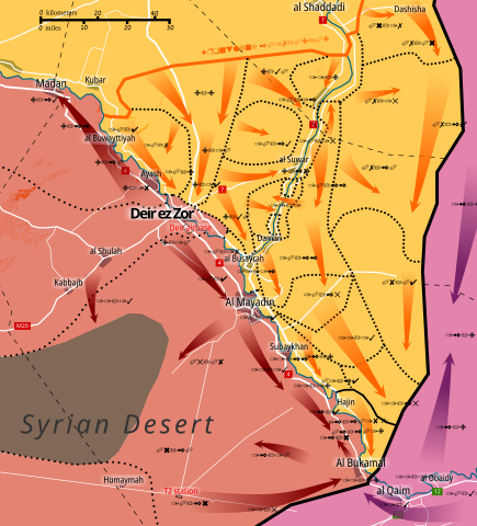
| Description | English: Map of SDF's Deir ez Zor/ Eastern Syria Offensive. Cropped from my Central Syria Campaign map. Made in Inkscape and influenced by many maps from creators: PetoLucem, A7_Mirza, SouthFront, and MrPenguin20. Controlled by the Syrian Democratic Forces Controlled by the Syrian Arab Republic Controlled by the Iraqi government Controlled by the Islamic State of Iraq and the Levant |
| Date | |
| Source | Own work based on: Race to Deir ezzor.svg |
| Author | Rr016 |
| SVG development |
Licensing
I, the copyright holder of this work, hereby publish it under the following license:
This file is licensed under the Creative Commons Attribution-Share Alike 4.0 International license.
- You are free:
- to share – to copy, distribute and transmit the work
- to remix – to adapt the work
- Under the following conditions:
- attribution – You must give appropriate credit, provide a link to the license, and indicate if changes were made. You may do so in any reasonable manner, but not in any way that suggests the licensor endorses you or your use.
- share alike – If you remix, transform, or build upon the material, you must distribute your contributions under the same or compatible license as the original.
File history
Click on a date/time to view the file as it appeared at that time.
| Date/Time | Thumbnail | Dimensions | User | Comment | |
|---|---|---|---|---|---|
| current | 15:28, 18 February 2019 | | 730 × 805 (610 KB) | AlAboud83 | Reverted to version as of 18:33, 17 February 2019 (UTC) SDF controls the Entire Hajin Pocket,and ISIS is just hiding in tunnels,ISIS still controls parts of Deir Ez Zor Badiyah |
| 13:50, 18 February 2019 |  | 730 × 805 (603 KB) | Iamtheman96 | Reverted to version as of 13:42, 29 September 2018 (UTC) | |
| 18:33, 17 February 2019 |  | 730 × 805 (610 KB) | Rr016 | An update as per NiaChampagne13's request | |
| 13:42, 29 September 2018 |  | 730 × 805 (603 KB) | Borinquen122617 | Reverted to version as of 19:58, 5 August 2018 (UTC) https://en.m.wikipedia.org/wiki/File:Syrian_Civil_War_map.svg | |
| 18:50, 2 September 2018 |  | 730 × 805 (605 KB) | Rr016 | Correction: ISIS still has presence in desert, added Hajjin to map | |
| 19:58, 5 August 2018 |  | 730 × 805 (603 KB) | Rr016 | update | |
| 16:03, 25 July 2018 |  | 730 × 805 (602 KB) | Rr016 | Update: ISIS expelled from Hasakah governorate | |
| 17:35, 7 July 2018 |  | 730 × 805 (594 KB) | Rr016 | Update | |
| 20:04, 9 December 2017 |  | 730 × 805 (582 KB) | Rr016 | Big update: ISF expel ISIS from Iraq, securing its borders; SAA encircled ISIS forces in Homs/Deir desert; SDF making advances towards the border. | |
| 20:38, 27 November 2017 |  | 730 × 805 (569 KB) | Rr016 | Update: enlarged map due to SDF reaching Iraqi border |
File usage
The following pages on the English Wikipedia use this file (pages on other projects are not listed):
Global file usage
The following other wikis use this file:
- Usage on ar.wikipedia.org
- Usage on azb.wikipedia.org
- Usage on be.wikipedia.org
- Usage on de.wikipedia.org
- Usage on es.wikipedia.org
- Usage on fa.wikipedia.org
- Usage on ru.wikipedia.org
- Usage on www.wikidata.org