File:Pas de Calais est.png
 From Wikipedia the free encyclopedia

Size of this preview: 800 × 595 pixels. Other resolutions: 320 × 238 pixels | 640 × 476 pixels | 860 × 640 pixels.
Original file (860 × 640 pixels, file size: 61 KB, MIME type: image/png)
| This is a file from the Wikimedia Commons. Information from its description page there is shown below. Commons is a freely licensed media file repository. You can help. |
Summary
 | This demographic map image could be re-created using vector graphics as an SVG file. This has several advantages; see Commons:Media for cleanup for more information. If an SVG form of this image is available, please upload it and afterwards replace this template with {{vector version available|new image name}}. It is recommended to name the SVG file “Pas de Calais est.svg”—then the template Vector version available (or Vva) does not need the new image name parameter. |
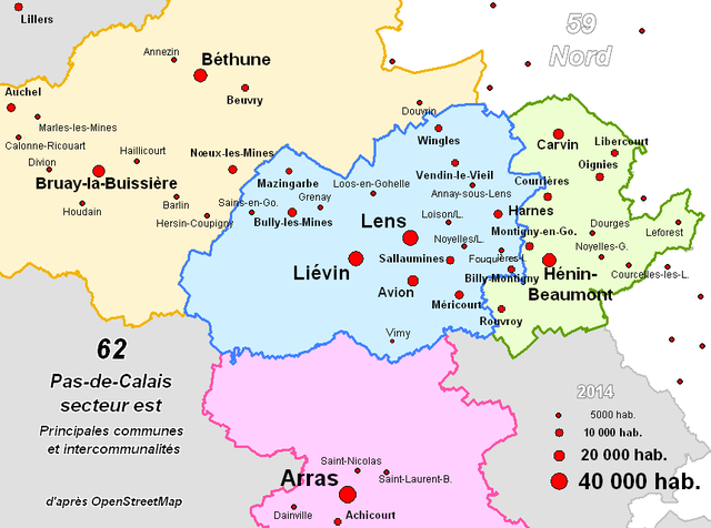
| Description | Carte de l'est du Pas-de-Calais (Béthune, Lens, Liévin, Arras, Hénin) avec les principales communes (5000 hab. et plus) et les principales intercommunalités mises à jour au 1er janvier 2014. |
| Date | 28 October 2003 (original upload date) |
| Source | Image composée par moi-même avec Mapinfo à partir des données OpenStreetMap. |
| Author | Hemmer at French Wikipedia |
Licensing
 | Permission is granted to copy, distribute and/or modify this document under the terms of the GNU Free Documentation License, Version 1.2 or any later version published by the Free Software Foundation; with no Invariant Sections, no Front-Cover Texts, and no Back-Cover Texts. A copy of the license is included in the section entitled GNU Free Documentation License. |
| This file is licensed under the Creative Commons Attribution-Share Alike 3.0 Unported license. | ||
| ||
| This licensing tag was added to this file as part of the GFDL licensing update. |
Original upload log
(All user names refer to fr.wikipedia)
- 2004-06-26 07:24 Hemmer 670×500×8 (14064 bytes) Rétablissement de la version précédente
- 2004-06-23 19:13 RenePawlicki 660×500×4 (9323 bytes) Rétablissement de la version précédente
- 2003-10-28 16:23 Hemmer 670×500×8 (14064 bytes) mise à jour
File history
Click on a date/time to view the file as it appeared at that time.
| Date/Time | Thumbnail | Dimensions | User | Comment | |
|---|---|---|---|---|---|
| current | 09:41, 10 January 2014 | | 860 × 640 (61 KB) | Hemmer | mise à jour des populations |
| 15:48, 9 January 2014 |  | 860 × 640 (53 KB) | Hemmer | Référence à OpenStreetMap | |
| 11:54, 9 January 2014 |  | 850 × 620 (49 KB) | Hemmer | mise à jour des intercommunalités | |
| 19:40, 31 January 2007 |  | 670 × 500 (14 KB) | Bilou~commonswiki | {{Information |Description=Carte de l'est du Pas-de-Calais (Béthune, Lens, Liévin, Arras, Hénin) |Source=Image composée par moi même avec Mapinfo par Hemmer, Composition "maison" simplifiée le 28/10/03 (contours des intercommunal |
File usage
The following pages on the English Wikipedia use this file (pages on other projects are not listed):
Global file usage
The following other wikis use this file:
- Usage on af.wikipedia.org
- Usage on ar.wikipedia.org
- Usage on azb.wikipedia.org
- Usage on ban.wikipedia.org
- Usage on eo.wikipedia.org
- Usage on es.wikipedia.org
- Usage on et.wikipedia.org
- Usage on fa.wikipedia.org
- Usage on fr.wikipedia.org
- Usage on id.wikipedia.org
- Usage on oc.wikipedia.org
- Usage on pcd.wikipedia.org
- Usage on sco.wikipedia.org
- Usage on uk.wikipedia.org
- Usage on www.wikidata.org