File:Ni-map.png
 From Wikipedia the free encyclopedia
No higher resolution available.
Ni-map.png (328 × 349 pixels, file size: 14 KB, MIME type: image/png)
| This is a file from the Wikimedia Commons. Information from its description page there is shown below. Commons is a freely licensed media file repository. You can help. |
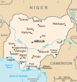
CIA map of Nigeria
This image is in the public domain because it contains materials that originally came from the United States Central Intelligence Agency's World Factbook.
|  |
derivative works
Derivative works of this file: Ni-map-sv.png
File history
Click on a date/time to view the file as it appeared at that time.
| Date/Time | Thumbnail | Dimensions | User | Comment | |
|---|---|---|---|---|---|
| current | 04:52, 12 February 2022 | | 328 × 349 (14 KB) | Lojwe | Cropped 1 % horizontally, 1 % vertically using CropTool with precise mode. |
| 20:54, 4 March 2005 |  | 331 × 352 (15 KB) | Alfio | CIA map of Nigeria |
File usage
The following pages on the English Wikipedia use this file (pages on other projects are not listed):
Global file usage
The following other wikis use this file:
- Usage on cv.wikipedia.org
- Usage on de.wikinews.org
- Usage on eo.wikipedia.org
- Usage on es.wikipedia.org
- Usage on et.wikipedia.org
- Usage on fi.wikivoyage.org
- Usage on gl.wikipedia.org
- Usage on ht.wikipedia.org
- Usage on hu.wikipedia.org
- Usage on hu.wiktionary.org
- Usage on it.wikipedia.org
- Usage on it.wikinews.org
- Usage on ja.wikipedia.org
- Usage on ja.wikinews.org
- Usage on la.wikipedia.org
- Usage on lfn.wikipedia.org
- Usage on mrj.wikipedia.org
- Usage on nn.wikipedia.org
- Usage on no.wikipedia.org
- Usage on pl.wikinews.org
- Usage on roa-tara.wikipedia.org
- Usage on ru.wikipedia.org
- Usage on scn.wikipedia.org
- Usage on sg.wikipedia.org
- Usage on sg.wiktionary.org
- Usage on sh.wikipedia.org
- Usage on sq.wikipedia.org
- Usage on sr.wikipedia.org
- Usage on ta.wikinews.org
- Usage on uk.wikipedia.org
- Usage on vls.wikipedia.org
View more global usage of this file.