File:Ma'aleh Akrabim.jpg
 From Wikipedia the free encyclopedia
Size of this preview: 800 × 516 pixels. Other resolutions: 320 × 206 pixels | 640 × 412 pixels | 1,024 × 660 pixels | 1,280 × 825 pixels | 2,560 × 1,650 pixels | 4,224 × 2,722 pixels.
Original file (4,224 × 2,722 pixels, file size: 8.96 MB, MIME type: image/jpeg)
| This is a file from the Wikimedia Commons. Information from its description page there is shown below. Commons is a freely licensed media file repository. You can help. |
| This is a featured picture, which means that members of the community have identified it as one of the finest images on the English Wikipedia, adding significantly to its accompanying article. If you have a different image of similar quality, be sure to upload it using the proper free license tag, add it to a relevant article, and nominate it. |
| This image was selected as picture of the day on the English Wikipedia for October 1, 2014. |
|
Summary
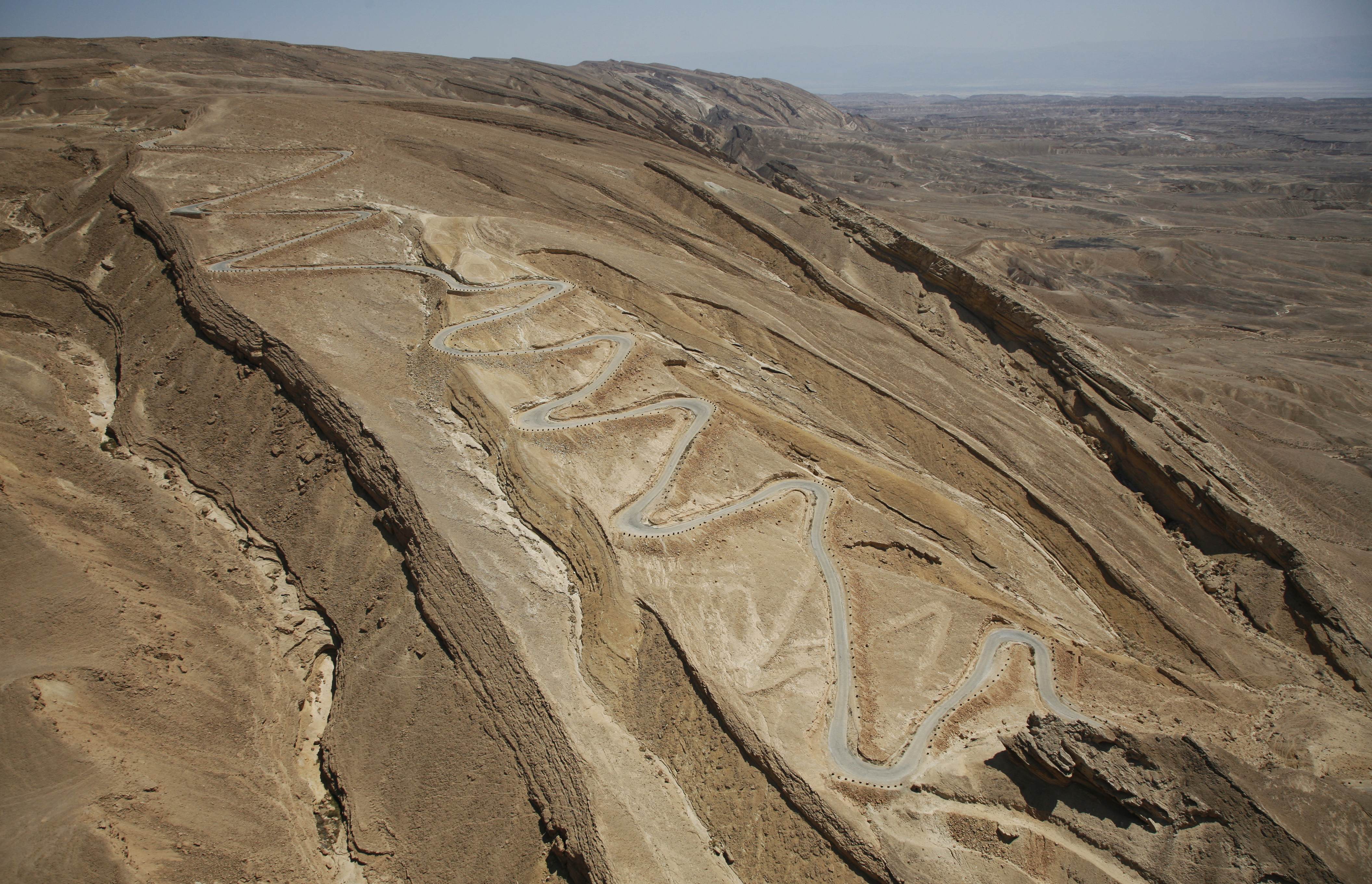
| Description | עברית: כביש מעלה העקרבים שימש עד 1956 כדרך הראשית לאילת המייחד את הכביש הן הסרפנטינות - שיטת סלילת דרך בריטית לירידה מפותלת בהדום ההר, מחוזקת בטרסות ומסומנת בחביות. כיום הכביש הוא אתר מורשת לשימור. במקום נקודת תצפית על הכביש , הערבה , נחל צין והדרך הרומית שעברה במקום - עם הסברים קצרים. English: Until 1956, the Scorpion Pass in Israel's Negev Desert was the main road to Eilat. The road was first built by the British in 1927 and uses the British construction style of a reinforced winding path, marked by barrels. Today the road is a heritage site in Israel, set to be preserved by the National Preservation Society. The site has plaques describing the history of the road and the surrounding geography.
| ||
| Date | |||
| Source | Own work | ||
| Author | אילן ארד |
| Camera location | | View this and other nearby images on: OpenStreetMap |
|---|
Licensing
I, the copyright holder of this work, hereby publish it under the following license:
This file is licensed under the Creative Commons Attribution-Share Alike 3.0 Unported license.
- You are free:
- to share – to copy, distribute and transmit the work
- to remix – to adapt the work
- Under the following conditions:
- attribution – You must give appropriate credit, provide a link to the license, and indicate if changes were made. You may do so in any reasonable manner, but not in any way that suggests the licensor endorses you or your use.
- share alike – If you remix, transform, or build upon the material, you must distribute your contributions under the same or compatible license as the original.
 | This image was nominated as a finalist in Wiki Loves Monuments 2012, the world's largest photo contest! |
 | This image was uploaded as part of Wiki Loves Monuments 2012.
|  |
File history
Click on a date/time to view the file as it appeared at that time.
| Date/Time | Thumbnail | Dimensions | User | Comment | |
|---|---|---|---|---|---|
| current | 21:04, 27 January 2013 | | 4,224 × 2,722 (8.96 MB) | Ynhockey | Removed spot on top-left |
| 11:51, 13 October 2012 |  | 4,224 × 2,722 (8.94 MB) | אילן ארד | User created page with UploadWizard |
File usage
The following pages on the English Wikipedia use this file (pages on other projects are not listed):
- Operation Lot
- Route 227 (Israel)
- Talk:Route 227 (Israel)
- User:Ynhockey/IsraelFPs
- User talk:Ynhockey/Archive21
- User talk:Ynhockey/Archive22
- Wikipedia:Featured picture candidates/February-2013
- Wikipedia:Featured picture candidates/Scorpion Pass
- Wikipedia:Featured pictures/Places/Others
- Wikipedia:Featured pictures thumbs/33
- Wikipedia:Main Page history/2014 October 1
- Wikipedia:Picture of the day/October 2014
- Wikipedia:WikiProject Israel
- Wikipedia:WikiProject Israel/Recognized content
- Wikipedia:Wikipedia Signpost/2012-11-05/News and notes
- Wikipedia:Wikipedia Signpost/2013-02-11/Featured content
- Wikipedia:Wikipedia Signpost/Single/2012-11-05
- Wikipedia:Wikipedia Signpost/Single/2013-02-11
- Template:Did you know nominations/Operation Lot
- Template:POTD/2014-10-01
Global file usage
The following other wikis use this file:
- Usage on ceb.wikipedia.org
- Usage on da.wikipedia.org
- Usage on es.wikipedia.org
- Usage on fa.wikipedia.org
- Usage on fr.wikipedia.org
- Usage on he.wikipedia.org
- טבח מעלה עקרבים
- מעלה עקרבים
- פורטל:תחבורה/תמונה נבחרת/גלריה
- כביש 227
- ויקיפדיה:מיזמי ויקיפדיה/ויקיפדיה אוהבת אתרי מורשת/מבוא/ללא לשוניות/תחרות 2012
- ויקיפדיה:מיזמי ויקיפדיה/ויקיפדיה אוהבת אתרי מורשת/ארכיון/תחרות 2012
- ויקיפדיה:תמונה מומלצת/הוספה למומלצים/ארכיון 46
- ויקיפדיה:תמונה מומלצת/המלצות קודמות/ינואר 2013
- פורטל:אתרי מורשת בישראל
- פורטל:אתרי מורשת בישראל/תמונה נבחרת/גלריה
- פורטל:אתרי מורשת בישראל/תמונה נבחרת/57
- פורטל:אתרי מורשת בישראל/תחרות ויקיפדיה אוהבת אתרי מורשת
- פורטל:אתרי מורשת בישראל/תחרות ויקיפדיה אוהבת אתרי מורשת 2012/3
- ויקיפדיה:מיזמי ויקיפדיה/ויקיפדיה אוהבת אתרי מורשת/זוכי התחרות בישראל 2012
- ויקיפדיה:מזנון/ארכיון 303
- תבנית:תמונה מומלצת 16 בינואר 2013
- ויקיפדיה:עמותת ויקימדיה ישראל/תמונה נבחרת/גלריה
- פורטל:ארכאולוגיה של המזרח הקרוב/רשימת אתרים ארכאולוגים בישראל/אתרים במחוז דרום
- ויקיפדיה:ויקימדיה ישראל/תמונה נבחרת/46
- ויקיפדיה:מיזמי ויקיפדיה/ויקיפדיה אוהבת אתרי מורשת/אתרי עתיקות בדרום הארץ/תחרות 2014
- ויקיפדיה:מיזמי ויקיפדיה/ויקיפדיה אוהבת אתרי מורשת/אתרי עתיקות בדרום הארץ/תחרות 2015
- ויקיפדיה:מיזמי ויקיפדיה/ויקיפדיה אוהבת אתרי מורשת/אתרי עתיקות בדרום הארץ/תחרות 2016
- ויקיפדיה:מיזמי ויקיפדיה/ויקיפדיה אוהבת אתרי מורשת/אתרי עתיקות בדרום הארץ/תחרות 2017
- ויקיפדיה:מיזמי ויקיפדיה/ויקיפדיה אוהבת אתרי מורשת/אתרי עתיקות בדרום הארץ/תחרות 2018
- ויקיפדיה:מיזמי ויקיפדיה/ויקיפדיה אוהבת אתרי מורשת/ארכיון/תחרות 2017
- ויקיפדיה:מיזמי ויקיפדיה/ויקיפדיה אוהבת אתרי מורשת/זוכי התחרות בישראל/תחרות 2017
- שיחה:סרפנטינות מעלה העקרבים
- סרפנטינות מעלה העקרבים
- ויקיפדיה:מיזמי ויקיפדיה/ויקיפדיה אוהבת אתרי מורשת/תחרות צילומים/ארכיון/תחרות 2020
- ויקיפדיה:מיזמי ויקיפדיה/ויקיפדיה אוהבת אתרי מורשת/אתרי עתיקות בדרום הארץ/תחרות 2020
- ויקיפדיה:מיזמי ויקיפדיה/ויקיפדיה אוהבת אתרי מורשת/זוכי התחרות בישראל 2020
- ויקיפדיה:מיזמי ויקיפדיה/ויקיפדיה אוהבת אתרי מורשת/זוכי התחרות בישראל 2021
- ויקיפדיה:מיזמי ויקיפדיה/ויקיפדיה אוהבת אתרי מורשת/אתרי עתיקות בדרום הארץ/תחרות 2021
- ויקיפדיה:מיזמי ויקיפדיה/ויקיפדיה אוהבת אתרי מורשת/תחרות צילומים/הסבר כללי
- פורטל:תחבורה/תמונה נבחרת/40
- Usage on vi.wikipedia.org
- Usage on www.wikidata.org