File:MBTA Commuter Rail and funding district map.svg
 From Wikipedia the free encyclopedia

Size of this PNG preview of this SVG file: 800 × 489 pixels. Other resolutions: 320 × 196 pixels | 640 × 392 pixels | 1,024 × 626 pixels | 1,280 × 783 pixels | 2,560 × 1,566 pixels | 904 × 553 pixels.
Original file (SVG file, nominally 904 × 553 pixels, file size: 2.37 MB)
| This is a file from the Wikimedia Commons. Information from its description page there is shown below. Commons is a freely licensed media file repository. You can help. |
Summary
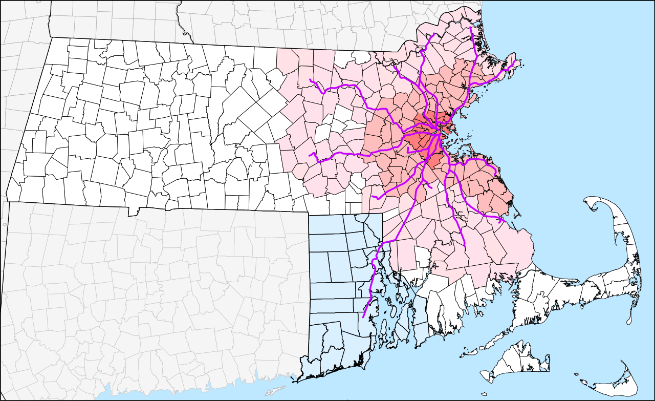
| Description | English: Geographic map of the MBTA Commuter Rail system and the MBTA funding district. The original 14-town MTA district is shown in darkest pink, the 78-town MBTA district established in 1964 in medium pink, and the 175-town "forward funding" district established in 1999 as light pink. White areas are not part of the MBTA district but still pay state sales taxes which are partially used to fund the MBTA. Rhode Island, which is not part of the district but pays for service to 3 stations under the 1988 Pilgrim Partnership, is shown in light blue. |
| Date | The map was originally uploaded on 29 March 2006. The latest version is accurate to the 23 April 2012 extension to Wickford Junction. |
| Source | Own work by User:Pi.1415926535 |
| Author | User:Pi.1415926535 (version 2) SPUI (version 1) |
| Other versions | Derivative works of this file: |
| SVG development |
Licensing
| I, the copyright holder of this work, release this work into the public domain. This applies worldwide. In some countries this may not be legally possible; if so: I grant anyone the right to use this work for any purpose, without any conditions, unless such conditions are required by law. |
File history
Click on a date/time to view the file as it appeared at that time.
| Date/Time | Thumbnail | Dimensions | User | Comment | |
|---|---|---|---|---|---|
| current | 20:46, 20 February 2014 | | 904 × 553 (2.37 MB) | Pi.1415926535 | Slight zoom in |
| 20:30, 20 February 2014 |  | 961 × 556 (2.51 MB) | Pi.1415926535 | Version 2.0.0: New version from all-new datasets. Town outlines from MassGIS, state outlines from USGS, and rail lines from article's KML file. Adjacent states have been added; some minor errors remain. | |
| 05:04, 3 August 2012 |  | 8,248 × 5,248 (4.97 MB) | Pi.1415926535 | Grouping etc. No visual changes to map. | |
| 04:53, 3 August 2012 |  | 8,248 × 5,248 (4.97 MB) | Pi.1415926535 | Adding Rhode Island map from File:Providence Metro Area.svg | |
| 03:08, 23 April 2012 |  | 8,248 × 5,248 (4.92 MB) | Pi.1415926535 | Wickford Junction opens tomorrow! | |
| 04:21, 13 July 2011 |  | 8,248 × 5,248 (4.92 MB) | Pi.1415926535 | Updated with under-construction Wachusett and Wickford Junction extensions. Grouped segments into lines for easier modification. (See talk page). | |
| 23:39, 14 May 2011 |  | 8,248 × 5,248 (4.9 MB) | Pi.1415926535 | T.F. Green Extension and Greenbush Line are now open since the creation of the map. Also added Wildcat (Wilmington) Branch between Lowell and Haverhill lines; it is used for some rush-hour trains. A few bits were ungrouped for ease of modification. | |
| 10:56, 29 March 2006 |  | 8,248 × 5,248 (4.84 MB) | SPUI~commonswiki | {{spuimap}} MBTA district. Old MTA district darkest, then original MBTA district, then 1999 expansion. Commuter Rail lines in purple, planned lines thinner and dashed. Data source: [http://www.mass.gov/mgis/download.htm Office of Geographic and Environme |
File usage
The following pages on the English Wikipedia use this file (pages on other projects are not listed):
Global file usage
The following other wikis use this file:
- Usage on de.wikipedia.org
- Usage on id.wikipedia.org
- Usage on ko.wikipedia.org
- Usage on simple.wikipedia.org
- Usage on sr.wikipedia.org
- Usage on www.wikidata.org
- Usage on zh-yue.wikipedia.org
- Usage on zh.wikipedia.org