File:LocationNSAm2.png
 From Wikipedia the free encyclopedia

Size of this preview: 600 × 600 pixels. Other resolutions: 240 × 240 pixels | 480 × 480 pixels.
Original file (800 × 800 pixels, file size: 21 KB, MIME type: image/png)
| This is a file from the Wikimedia Commons. Information from its description page there is shown below. Commons is a freely licensed media file repository. You can help. |
Summary
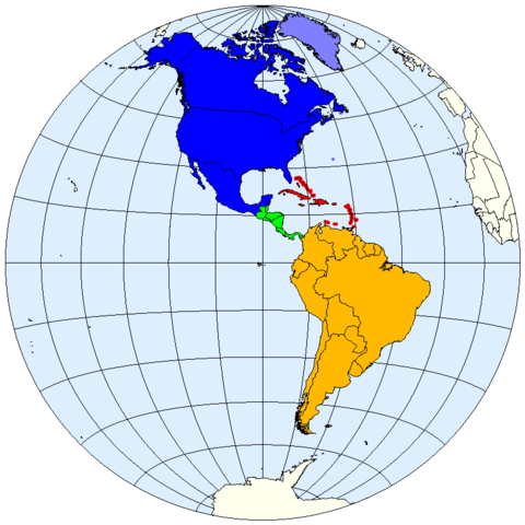
| Description | Division of the Americas into North, Central and South America and the West Indies. |
| Date | |
| Source | prepared from public domain maps created by w:en:User:E Pluribus Anthony. |
| Author | Spacepotato |
Legend
- 0000FF: North America.
- 8080FF: Sometimes included in North America.
- 00FF06: Central America.
- FF0000: West Indies.
- FFBA00: South America.
References
- MSN Encarta archive copy at the Wayback Machine, Microsoft. Accessed on line October 15, 2007. Divides the Western Hemisphere into North America, Central America, the West Indies, and South America.
- "North America archive copy at the Wayback Machine". MSN Encarta, Microsoft. Accessed on line October 11, 2007. Defines North America as including Canada, the USA, Mexico, Greenland, St. Pierre and Miquelon, and Bermuda.
- "Central America archive copy at the Wayback Machine". MSN Encarta, Microsoft. Accessed on line October 12, 2007. Defines Central America as including Belize, Costa Rica, El Salvador, Guatemala, Honduras, Nicaragua, and Panama.
Licensing
| I, the copyright holder of this work, release this work into the public domain. This applies worldwide. In some countries this may not be legally possible; if so: I grant anyone the right to use this work for any purpose, without any conditions, unless such conditions are required by law. |
See also
- Image:LocationNSAm.png
- Image:LocationNSAm3.png
- Image:LocationNSAngloLatin.png
- Image:LocationNSAmUNGeoscheme.png
File history
Click on a date/time to view the file as it appeared at that time.
| Date/Time | Thumbnail | Dimensions | User | Comment | |
|---|---|---|---|---|---|
| current | 00:40, 12 October 2007 | | 800 × 800 (21 KB) | Spacepotato | |
| 22:03, 11 October 2007 |  | 800 × 798 (21 KB) | Spacepotato | == Summary == {{Information |Description=Division of the Americas into North, Central and South America and the West Indies. |Source=prepared from public domain maps created by w:en:User:E Pluribus Anthony. |Date=October 11, 2007. |Author= [[User:Spac |
File usage
The following pages on the English Wikipedia use this file (pages on other projects are not listed):
Global file usage
The following other wikis use this file:
- Usage on ar.wikipedia.org
- Usage on bn.wikipedia.org
- Usage on ca.wikipedia.org
- Usage on eu.wikipedia.org
- Usage on kn.wikipedia.org
- Usage on pt.wikipedia.org