File:Hatteras Island damage by Hurricane Isabel.jpg
 From Wikipedia the free encyclopedia

Size of this preview: 800 × 536 pixels. Other resolutions: 320 × 215 pixels | 640 × 429 pixels | 1,024 × 687 pixels | 1,280 × 858 pixels | 2,560 × 1,717 pixels | 3,054 × 2,048 pixels.
Original file (3,054 × 2,048 pixels, file size: 601 KB, MIME type: image/jpeg)
| This is a file from the Wikimedia Commons. Information from its description page there is shown below. Commons is a freely licensed media file repository. You can help. |
Summary
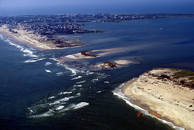
Hurricane Isabel breached one of the barrier islands in North Carolina http://coastal.er.usgs.gov/hurricanes/isabel/airphotos/medium/46_9_21_03_14.jpg http://coastal.er.usgs.gov/hurricanes/isabel/site-index.php?storm_id=4&site_id=12
| Object location | | View this and other nearby images on: OpenStreetMap |
|---|
Licensing
This image is in the public domain in the United States because it only contains materials that originally came from the United States Geological Survey, an agency of the United States Department of the Interior. For more information, see the official USGS copyright policy.
|
File history
Click on a date/time to view the file as it appeared at that time.
| Date/Time | Thumbnail | Dimensions | User | Comment | |
|---|---|---|---|---|---|
| current | 15:31, 13 August 2016 | | 3,054 × 2,048 (601 KB) | TheAustinMan | Replace with highest resolution available |
| 16:27, 1 March 2006 |  | 768 × 512 (55 KB) | Storm05~commonswiki | Hurricane Isabel breached one of the barrier islands in North Carolina http://coastal.er.usgs.gov/hurricanes/isabel/airphotos/medium/46_9_21_03_14.jpg http://coastal.er.usgs.gov/hurricanes/isabel/site-index.php?storm_id=4&site_id=12 |
File usage
The following pages on the English Wikipedia use this file (pages on other projects are not listed):
- Cape Hatteras
- Effects of Hurricane Isabel in North Carolina
- Hurricane Isabel
- Isabel Inlet
- List of North Carolina hurricanes
- List of North Carolina hurricanes (2000–present)
- User:Sushant gupta/Ebox
- Wikipedia:Featured and good topic candidates/Addition log/May 2010
- Wikipedia:Featured and good topic candidates/Lists of North Carolina hurricanes/addition1
- Wikipedia:Featured topics
- Wikipedia:Featured topics/Lists of North Carolina hurricanes
- Wikipedia:Main Page history/2018 September 18
- Wikipedia:Today's featured article/September 18, 2018
- Wikipedia:Today's featured article/September 2018
- Wikipedia:Today's featured article/requests/Effects of Hurricane Isabel in North Carolina
Global file usage
The following other wikis use this file:
- Usage on ar.wikipedia.org
- Usage on de.wikipedia.org
- Usage on es.wikipedia.org
- Usage on fr.wikipedia.org
- Usage on pt.wikipedia.org
- Usage on ru.wikipedia.org
- Usage on uk.wikipedia.org
- Usage on vi.wikipedia.org
- Usage on zh.wikipedia.org