File:Damascus offensive (February 2013).svg
 From Wikipedia the free encyclopedia

Size of this PNG preview of this SVG file: 800 × 523 pixels. Other resolutions: 320 × 209 pixels | 640 × 419 pixels | 1,024 × 670 pixels | 1,280 × 837 pixels | 2,560 × 1,674 pixels | 1,856 × 1,214 pixels.
Original file (SVG file, nominally 1,856 × 1,214 pixels, file size: 9.32 MB)
| This is a file from the Wikimedia Commons. Information from its description page there is shown below. Commons is a freely licensed media file repository. You can help. |
.svg)
Summary
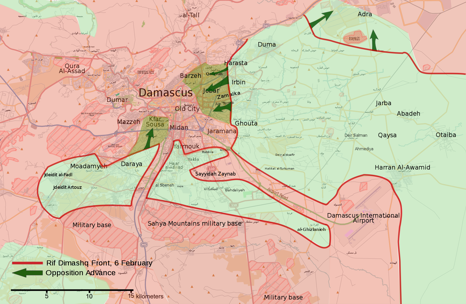
| Description | English: Map of the February 2013 Damascus offensive. العربية: خريطة هجوم فبراير 2013 في دمشق. |
| Source | Own work, OpenStreetMap |
| Author | MrPenguin20 |
Licensing
| This work contains information from OpenStreetMap, which is made available under the Open Database License (ODbL). The ODbL does not require any particular license for maps produced from ODbL data. Prior to 1 August 2020, map tiles produced by the OpenStreetMap Foundation were licensed under the CC-BY-SA-2.0 license. Maps produced by other people may be subject to other licences. |
This file is licensed under the Creative Commons Attribution-Share Alike 3.0 Unported license.
- You are free:
- to share – to copy, distribute and transmit the work
- to remix – to adapt the work
- Under the following conditions:
- attribution – You must give appropriate credit, provide a link to the license, and indicate if changes were made. You may do so in any reasonable manner, but not in any way that suggests the licensor endorses you or your use.
- share alike – If you remix, transform, or build upon the material, you must distribute your contributions under the same or compatible license as the original.
File history
Click on a date/time to view the file as it appeared at that time.
| Date/Time | Thumbnail | Dimensions | User | Comment | |
|---|---|---|---|---|---|
| current | 16:27, 6 August 2018 | | 1,856 × 1,214 (9.32 MB) | Rr016 | Filled in empty spaces, as per AlAboud83's request |
| 16:04, 27 September 2013 |  | 1,856 × 1,214 (9.31 MB) | MrPenguin20 | Fixed so Army Base south of Adra remains in SAA hands. | |
| 01:04, 21 September 2013 |  | 1,856 × 1,214 (9.32 MB) | MrPenguin20 | Fixed key | |
| 23:19, 20 September 2013 |  | 1,856 × 1,214 (9.32 MB) | MrPenguin20 | {{Information |Description ={{en|1=Map of the February 2013 Damascus offensive.}} |Source ={{Own}}, OpenStreetMap |Author =MrPenguin20 |Date = |Permission = |other_versions = }} [[Category:Maps of ... |
File usage
The following pages on the English Wikipedia use this file (pages on other projects are not listed):
Global file usage
The following other wikis use this file:
- Usage on ar.wikipedia.org
- Usage on fr.wikipedia.org
- Usage on it.wikipedia.org
- Usage on ru.wikipedia.org
- Usage on tr.wikipedia.org
- Usage on www.wikidata.org
- Usage on zh.wikipedia.org
.svg)