File:Baden-Wuerttemberg relief location map.jpg
 From Wikipedia the free encyclopedia

Size of this preview: 530 × 599 pixels. Other resolutions: 212 × 240 pixels | 425 × 480 pixels | 679 × 768 pixels | 906 × 1,024 pixels | 1,673 × 1,891 pixels.
Original file (1,673 × 1,891 pixels, file size: 1.32 MB, MIME type: image/jpeg)
| This is a file from the Wikimedia Commons. Information from its description page there is shown below. Commons is a freely licensed media file repository. You can help. |
Summary
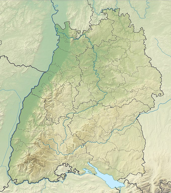
| Description | Quadratische Plattkarte. Geographische Begrenzung der Karte:
Equirectangular projection. Geographic limits of the map:
|
| Date | |
| Source | Own work |
| Author | Grundkarte kjunix, Relief Alexrk2 |
| Other versions |
|

Licensing
I, the copyright holder of this work, hereby publish it under the following licenses:
 | Permission is granted to copy, distribute and/or modify this document under the terms of the GNU Free Documentation License, Version 1.2 or any later version published by the Free Software Foundation; with no Invariant Sections, no Front-Cover Texts, and no Back-Cover Texts. A copy of the license is included in the section entitled GNU Free Documentation License. |
This file is licensed under the Creative Commons Attribution-Share Alike 3.0 Unported license.
- You are free:
- to share – to copy, distribute and transmit the work
- to remix – to adapt the work
- Under the following conditions:
- attribution – You must give appropriate credit, provide a link to the license, and indicate if changes were made. You may do so in any reasonable manner, but not in any way that suggests the licensor endorses you or your use.
- share alike – If you remix, transform, or build upon the material, you must distribute your contributions under the same or compatible license as the original.
You may select the license of your choice.
File history
Click on a date/time to view the file as it appeared at that time.
| Date/Time | Thumbnail | Dimensions | User | Comment | |
|---|---|---|---|---|---|
| current | 17:10, 15 November 2009 | | 1,673 × 1,891 (1.32 MB) | Alexrk2 | == {{int:filedesc}} == {{Information |Description= {{de|Physische Positionskarte von Baden-Württemberg, Deutschland}} Quadratische Plattkarte. Geographische Begrenzung der Karte: * N: 49.89926° N * S: 47.42 |
File usage
More than 100 pages use this file. The following list shows the first 100 pages that use this file only. A full list is available.
- Achalm (Mountain)
- Ammer (Neckar)
- Amorsbach
- Annasee
- Arlesheimer See
- Atzenberger Höhe
- Augstberg
- Badener Höhe
- Baggersee Lutz
- Battert
- Battle of Freiburg
- Belchen
- Birkenkopf
- Blasenberg (Swabian Jura)
- Blauen (Badenweiler)
- Brandeckkopf
- Brend (mountain)
- Bromberg (Schönbuch)
- Bussen
- Capture of Mannheim
- Doc Salbe PGA European Challenge
- Einkorn (hill)
- Feldberg (Black Forest)
- Franco-Spanish War (1635–1659)
- Fremersberg
- Fuchseck
- Geissenklösterle
- Gräbelesberg
- Hasenhorn
- Himberg (Swabian Jura)
- Hinterwaldkopf
- Hochberg (Swabian Jura)
- Hochfirst (Black Forest)
- Hochkopf (Southern Black Forest)
- Hohe Möhr
- Hohe Warte (Swabian Jura)
- Hohenheim Castle
- Hohenhewen
- Hohenstaufen (mountain)
- Hohentwiel
- Hohle Fels
- Hohlenstein-Stadel
- Hornisgrinde
- Hummelsberg (Swabian Jura)
- Hundsrücken (Swabian Jura)
- Höchsten
- Hörnle (Swabian Jura)
- Hörnleberg
- Hünersedel
- Iberger Kugel
- Ipf (mountain)
- Kaiserstuhl (Baden-Württemberg)
- Kandel (mountain)
- Katzenbuckel
- Königstuhl (Odenwald)
- Lake Constance
- Lemberg (Swabian Jura)
- Maulbronn Monastery
- Max-Eyth-See
- Merkur (mountain)
- Moos (mountain)
- Mummelsee
- Obereck
- Oberhohenberg
- Obersee (Lake Constance)
- Ochsenberg (Swabian Jura)
- Ottilienberg
- Plettenberg (mountain)
- Raichberg
- Rainen
- Rohrenkopf
- Rohrhardsberg
- Rosenstein (Swabian Jura)
- Roßberg (Swabian Jura)
- Roßkopf (Breisgau)
- Römerstein (mountain)
- Schafberg (Swabian Jura)
- Schauinsland
- Schliffkopf
- Schnarrenberg (Stuttgart)
- Schussen
- Schönberg (Ebringen)
- Seebuck
- Seekopf (Seebach)
- Stöcklewald
- Stübenwasen
- Teckberg
- Titisee
- Totenkopf (hill)
- Uhlberg
- Untersee (Lake Constance)
- Verband Deutscher Prädikatsweingüter
- Wandbühl
- Wasserberg (Swabian Jura)
- Weissenhof Estate
- Weißer Stein
- Wildsee (Kaltenbronn)
- Windgfällweiher
- Wirtemberg Castle
- Yavuz Sultan Selim Mosque
View more links to this file.
Global file usage
The following other wikis use this file:
- Usage on als.wikipedia.org
- Feldberg im Schwarzwald
- Burg Rötteln
- Schluchsee (See)
- Schönberg (Ebringen)
- Hohfirst
- Kandel (Berg)
- Blauen (Badenweiler)
- Totenkopf (Kaiserstuhl)
- Schneeburg
- Rohrhardsberg
- Brend (Berg)
- Hochfirst
- Lützelhardt
- Burg Höhingen
- Hünersedel
- Hörnleberg
- Simonswälder Tal
- Reichenau
- Rührberg (Grenzach-Wyhlen)
- Hardberg
- Burg Meersburg
- Burg Wildenstein (Leibertingen)
- Vorlage:Positionskarte Deutschland Baden-Württemberg
- Burg Lichtenberg (Oberstenfeld)
- Hohenstaufen (Berg)
- Burg Hohenstaufen
- Burg Zähringen (Freiburg)
- Mummelsee
- Federsee
- Ipf
- Bussen
- Teckberg
- Burg Neuenfels
- Burg Alt-Urach
- Burg Stallegg
- Burg Hauenfels
- Alt-Geroldseck
- Burg Bärenburg (Ramsbach)
- Burg Bosenstein
- Ruine Diersburg
- Hohengeroldseck
- Burg Husen
- Burg Neuenstein (Hubacker)
- Burg Neu-Windeck
- Schauenburg (Oberkirch)
- Ruine Wolfach
- Ruine Birchiburg
- Burg Falkenstein (Höllental)
- Burg Staufen (Schwarzwald)
- Burg Wiesneck
View more global usage of this file.