Cầu Giấy district
 From Wikipedia the free encyclopedia
Cầu Giấy district Quận Cầu Giấy | |
|---|---|
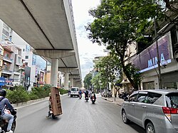
 Cầu Giấy road with the Hanoi Metro line 2 above | |
| Etymology: Cầu Giấy bridge | |
 | |
| Country | |
| Region | Red River Delta |
| Province | Hanoi |
| Commune-level town founding | 13 October 1982 |
| District founding | 22 November 1996 |
| Wards | 8[1] |
| Government | |
| • Type | District-level government |
| • People's Committee President | Bùi Tuấn Anh |
| • People's Council President | Nguyễn Văn Chiến |
| • People's Committee Secretary | Trần Thị Phương Hoa |
| Area | |
| • Total | 12.32 km2 (4.76 sq mi) |
| Population (2019)[2] | |
| • Total | 292,536 |
| • Density | 24,000/km2 (61,000/sq mi) |
| Time zone | UTC+7 (ICT) |
| Postal codes in Vietnam | 113xx |
| Area code | 24 |
| Website | caugiay.hanoi.gov.vn |

Cầu Giấy district (lit. Paper Bridge district) is an urban district of Hanoi, the capital city of Vietnam.[3] The district is named after the historic bridge where the Battle of Cầu Giấy was fought.
Many new urban developments are located in Cầu Giấy. Among them, Trung Hoà - Nhân Chính is emerging as the new city's commercial center. It lies partly in the southern part of the district (Trung Hoà ward). The massive Keangnam Hanoi Landmark Tower, the tallest building in Hanoi and second tallest building in Vietnam, is also located in this area.
History[edit]
The modern incarnation of Cầu Giấy district was formed on 22 November 1996, via the merger of four towns (Cầu Giấy, Nghĩa Đô, Nghĩa Tân, Mai Dịch) and three communes (Dịch Vọng, Yên Hòa, Trung Hòa) within the old Từ Liêm district. All towns and communes were reclassified to wards, and Cầu Giấy town was renamed to Quan Hoa ward.[4]
On 5 January 2005, Quan Hoa and Dịch Vọng ward's border was slightly adjusted to form the new Dịch Vọng Hậu ward.[5] On 1 January 2021, the border of Nghĩa Tân and Mai Dịch wards was slightly expanded, reducing the nearby Bắc Từ Liêm and Nam Từ Liêm district area.[6]
Administrative divisions[edit]
The district is divided into eight wards (phường):
References[edit]
- ^ a b "Niên giám thống kê năm 2018". Archived from the original on 2021-06-03. Retrieved 2021-02-21.
- ^ General Statistics Office of Vietnam (2019). "Completed Results of the 2019 Viet Nam Population and Housing Census" (PDF). Statistical Publishing House (Vietnam). ISBN 978-604-75-1532-5.
- ^ "Hà Nội có thêm năm quận mới vào năm 2025". VnExpress. 2019-10-30.
- ^ "Nghị định 74-CP thành lập quận Thanh Xuân, quận Cầu Giấy, thành lập và đổi tên một số phường thuộc thành phố Hà Nội - bản lưu trữ". thuvienphapluat.vn.
- ^ "Nghị định 02/2005/NĐ-CP điều chỉnh địa giới hành chính, thành lập phường thuộc quận Ba Đình, Cầu Giấy thành lập thị trấn Trâu Quỳ Gia Lâm Hà Nội - bản lưu trữ". thuvienphapluat.vn.
- ^ "Nghị quyết số 1263/NQ-UBTVQH14 năm 2021 về việc điều chỉnh địa giới đơn vị hành chính giữa các quận Cầu Giấy, Bắc Từ Liêm và Nam Từ Liêm thuộc thành phố Hà Nội".

