Balnain
 From Wikipedia the free encyclopedia
Balnain
| |
|---|---|
 A view of Balnain in 1999 | |
 Balnain Location within the Inverness area | |
| Population | 300 (1991) estimated |
| 'Under 1,000'[1] (2011) estimated | |
| OS grid reference | NH433305 |
| Council area | |
| Country | Scotland |
| Sovereign state | United Kingdom |
| Postcode district | IV63 6[2] |
| Police | Scotland |
| Fire | Scottish |
| Ambulance | Scottish |
| UK Parliament |
|
Balnain (Scottish Gaelic: Baile an Fhàin) is a small village in Glenurquhart, Scotland, about 5 miles west of Drumnadrochit. It is mostly dependent on tourism, forestry, agriculture and farming. The first buildings were created in the 1870s and 1880s and minor expansions occurred in the 1900s, 1960s and 1970. Its height above sea level is 123.6m.[2]
Overview[edit]
The River Enrick runs past the village and through to Loch Meiklie.[3][4][5] The village also has a primary school.[6][7][8][9][10][11][12][13]
Balnain is a small village 5 miles north of Glenurquhart, Scotland. The River Enrick runs past the village and through to Loch Meiklie. The local guest house was called Meiklie House, but is now Glenurquhart House.
History[edit]
Balmacaan Estate[edit]
Much of Glenurquhart was part of the Balmacaan Estate[14][15] (AKA: The Glen Urquhart Estate),[16] owned by the Grant family of Seafield between 1509 and 1946.[14][15] The estate It was rented to the wealthy American industrialist and local benefactor Bradley Martin late 19th and early 20th century [17] and flourished in the 1880s and 1890s, but went into decline after the 1920s.[14][15] The estate then changed hands frequently enough that the issue was raised in parliament [18][19] The best forestry wood had been felled during World War 2[16][20][21][22] and the estate was dissolved in 1946.[14][15] Balmacaan House, near Drumnadrochit, was abandoned soon afterwards[21][20][22][14][15][16] set on fire by vandals in the 1960s and demolished in 1972.[15][20][21][14][16][22]
In 1946 Bunloit Farm was separated from Balmacaan Estate and Bunloit Estate was formed around it.[23][24] near the small settlement of Balbeg, located on the north west shore of Loch Ness, about 4 miles south of Drumnadrochit.[23][24]
Origins[edit]
The people were originally from Balnain\Rogie near Castle Leod,[25] 27 miles north of Loch Meiklie,[25] in today's Torrachilty forest.[26]
It was first mentioned in a 1610 charter as the: '"fishings in the Linn of Coul, called Rogie" (NAS GD1/1149/4) [27]
In 1681 it was in the possession of Alexander Mackenzie of Coul in 1681.[25]
A historic quote from the mid 18th century reads:
- “Our first observation has to be that when the sheep farm at Rogie came into being there was a massive clearance of people from the old township of Balnain.”[25]
The last resident, William Macrae, appeared for the last time in the 1947/1948 Valuation Rolls.[27]
Its ruins are now referred to as Rogie or Rogg and are a listed archeological site.[25]
The village[edit]
Much of Glenurquhart, was part of the Balmacaan Estate owned by the Grant family of Seafield between 1509 and 1946 [14][15] The estate forished in the 1880s and 1890s, but went in to decline after the 1920s.[14][15] The best wood had been felled during World War 2 and the estate was desolved in 1946.[14][15] Balmacaan House, near Drumnadrochit, was abandoned soon afterwards, set on fire by vandals in the 1960s and demolished in 1972.[14][15]
Glenurquhart used to be part of the lands of the Grants of Glenmorison, with the lands of the Frasers to the north for most of its time. The Fraser family of Balnain, Scotland, supported Bonnie Prince Charlie.,[28] but came from a township of the same name, in Stratherrick on the other side of Loch Ness.
It was called Lochlater the mid 1700s, after Loch Meiklie's old name of Loch Later.[25]
Balnain had yet to exist by 1832, other than just the near by house of Lakefield and Lochlater had also ceased to be by that date.[29] Loch Meiklie was also known as Loch Loitter at this time [29] and possibly the nomenclatural origin of the near by settlement of Lochletter, Lochletter House and Lochletter forest. The River Enrick was known as Endrie Water at this time.[29]
Several buildings were erected during 1872, appearing on some maps, but not others. [30][31][32]
Hazlebrea House, Lochletter House, 9 Balnain houses, a barn and the smithy were there in 1878[33] and 1896.[34]
The primary school is of a Victorian origin and appeared in 1898 as an ordinary building,[35][36] but became a school by 1908.[37]
Sraid-Na-Fiffin Street was built in the mid 1970s.
Climate[edit]
Like most of the United Kingdom, the Inverness area has an oceanic climate (Köppen: Cfb).[38]
The weather in the village is generally warm and sunny in the spring and summer, cool and fairly rainy in the autumn, and very cold and snowy with some blizzards in the winter.
Local amenities[edit]

Recreational areas and parks
- Balnain-park is a play park.[39]
Public house
Post office
- It closed circa 1998, when the owner retired.
Balnain bike park
- The Forestry Commission's adventure bike park was opened in early 2009 and was closed in May 2011.[43][44][45][46][47][48][49]
Primary school[edit]

It is a non-denominational,[7][54][55][56][57] mixed sex school,[57][58][54][55][56][7][59] with 37 pupils in 2012,[57] but this was reduced to 35 pupils in as of 2013.[60]
The main school building was built in circa 1880.[35] The school did well in its 2006 and 2008 Ofsted reports. The leaky roof was fixed in 2008 after an Ofsted report commented on it 2 years earlier.[7][59][61]
A defibrillator was installed in the school in 2017.[53]
The headmistress was Mrs. M. L. Livingstone in 2010 and 2011.[7][54][55][56] Ms. Stephanie Wood took over by[60] In 2015, Miss Janis MacRae became Head but was shortly delayed after she broke her ankle.[60]
Julie MacLeod became head teacher by 2021.[62][63]
The School's opening hours in 2010 and now 2011 were 09.00 to 15.00 on week days in 2010 and 2011[7] Monday to Thursday 08.50 to 15.10 Friday 08.50 to 12.25. in 2021[62][63]
There are regular after-school activities for between the ages of 5 and 12 in 2012.[7][54][55][56]
The age bracket was 4 to 12 up to 2012.[7][54][55][56][57] The top age was cut from 12 to 11 during 2012.[57] The schools age bracket was redefined as 3 to 12 years old by 2021.[62][63]
Balnain Primary School's Folk Group won the Inverness Mod in 2018. [64]
The school uniform is a red Balnain School sweatshirt, with either grey trousers, pinafores or skirts and white or red polo shirt, or a white shirt.[65]
A red hoody and fleece since has also been issued since 2017 [64][66][67]
The Hockey\shinty kit was a navy blue and white T-shirt (unisex), jumper (girls), shorts (unisex) and black leggings (girls) 2017-2020. [66]
Transport[edit]
There was an occasional weekday bus service to Inverness (as of 1990–2005), which is now only twice daily. The bus stop is on the junction between the A831 and School Road End.[68] Road transport is often disrupted by harsh winter weather during December and January.
Nearby satellite settlements[edit]
Several small near-by settlements include: Strathnacro, Balnaglack, Balbeg, Uppertown, Balnalurigan and Lochletter Cottages.
.jpg)
.jpg)
Local attractions[edit]
The Forestry Commission closed the 2-year-old Bike-park and general access to cross-country cyclists in 2011,[48][69][70] but walkers can still enjoy the scenery.[71]
The annual Snowman Car Rally has passed through it since 1998.[72]
Political representation[edit]
It has been part of following Westminster constituencies:
- Inverness-shire (UK Parliament constituency) 1708-1918
- Inverness (UK Parliament constituency) 1918-1983
- Ross, Cromarty and Skye (UK Parliament constituency) 1983-1997
- Ross, Skye and Inverness West (UK Parliament constituency) 1997-2005
- Inverness, Nairn, Badenoch and Strathspey (UK Parliament constituency) 2005-to date
Gallery[edit]
-
![A picture of the forests above Balnain in 1999.[69]](//upload.wikimedia.org/wikipedia/commons/thumb/9/94/Balnain17.png/120px-Balnain17.png) A picture of the forests above Balnain in 1999.[69]
A picture of the forests above Balnain in 1999.[69] -
 A picture of Balnain in 1996.
 -
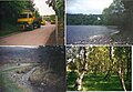 4 images of Balnain Village in 1998. The local loch is top right.
 -
 4 images of Balnain Village in 1998.
 -
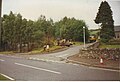 A picture Balnain in 1998. The Shelter by the workmen is the new 1990s bus shelter and the white concrete shelter behind the van is the old 1970s bus shelter.
 -
 A picture of Balnain in the winter 1995.
 -
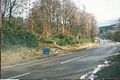 The road in to Balnain in 1998.
 -
 Lock Loch Meiklie seen from Balnaglack.
![A picture of the forests above Balnain in 1999.[69]](File:Balnain17.png)


.jpg)
_1.jpg)
See also[edit]
References[edit]
- ^ "Map of Balnain, United Kingdom, Europe". Collins Maps. Archived from the original on 23 July 2012. Retrieved 18 October 2011.
- ^ a b "#GetOutside: do more in the British Outdoors". OS GetOutside.
- ^ "Loch Meiklie area – map of – Loch Meiklie, Highland – at". Pagemost.com. Archived from the original on 20 October 2011. Retrieved 18 October 2011.
- ^ "Loch Meiklie". Am Baile. Retrieved 18 October 2011.
- ^ "Photo of Scotland – Loch Meiklie, Balnain". Panoramio. Archived from the original on 25 September 2011. Retrieved 18 October 2011.
- ^ "Geograph:: Balnain Primary School © Craig Wallace cc-by-sa/2.0". www.geograph.org.uk.
- ^ a b c d e f g h "Balnain Primary School". Highland.gov.uk. 24 August 2011. Archived from the original on 6 March 2012. Retrieved 18 October 2011.
- ^ "Balnain Primary School Drumnadrochit, Inverness, Schools and Colleges". Misterwhat.co.uk. Retrieved 18 October 2011.
- ^ "Balnain Primary School – IV63 6TJ – Inverness". Yelp.co.uk. Retrieved 18 October 2011.
- ^ "Balnain Primary School – Highland, Scotland". Friendsreunited.co.uk. Retrieved 18 October 2011.
- ^ "Map – Directions | Balnain Primary School | Schools & Colleges, Inverness". Yell.com. Retrieved 18 October 2011.
- ^ "Schools Local Authority in Inverness – Balnain Primary School". ThomsonLocal.com. Retrieved 18 October 2011.
- ^ "Highlands and Islands schools to receive renewable energy toolkits". Hi-energy.org.uk. 9 September 2008. Retrieved 18 October 2011.
- ^ a b c d e f g h i j "Local History: Drumnadrochit, Scotland—The Appendix". theappendix.net.
- ^ a b c d e f g h i j Trust, Woodland. "Balmacaan - Visiting Woods". Woodland Trust.
- ^ a b c d "Balmacaan House | Canmore". canmore.org.uk.
- ^ "On Balmacaan Estate". Am Baile.
- ^ "Balmacaan Estate (Hansard, 26 October 1943)". api.parliament.uk.
- ^ "Balmacaan Estate, Inverness-Shire - Hansard - UK Parliament". localhost.
{{cite web}}: Check|url=value (help) - ^ a b c "Architecture Notes | Canmore". canmore.org.uk.
- ^ a b c "Balmacaan House | Canmore". canmore.org.uk.
- ^ a b c "Balmacaan House | Canmore". canmore.org.uk.
- ^ a b "Loch Ness and mountains from a Highland estate". 6 June 2019.
- ^ a b "Bunloit Farm, Bunloit, Drumnadrochit, Inverness, IV63 6XG". www.ukpostcodecheck.com.
- ^ a b c d e f Nicholson, Diane (16 August 2020). "The Mystery of Balnain..."
- ^ "Rogie". Forestry and Land Scotland.
- ^ a b Archaeological Remains at Rogie, Ross-shire NOSAS
- ^ "Revolutionary War - Gen. Cornwallis". Archived from the original on 23 January 2015. Retrieved 3 May 2013.
- ^ a b c "Inverness Shire 5 N." www.davidrumsey.com.
- ^ "View map: Inverness-shire - Mainland XXIX.5 (Urquhart & Glenmoriston) - Ordnance Survey 25 inch 1st edition, Scotland, 1855-1882". maps.nls.uk.
- ^ "View map: Inverness-shire - Mainland XXIX.9 (Urquhart & Glenmoriston) - Ordnance Survey 25 inch 1st edition, Scotland, 1855-1882". maps.nls.uk.
- ^ "Scotland". www.davidrumsey.com.
- ^ "View map: One-inch 1st Edition, Scotland: sheet 73 - Fort Augustus - Ordnance Survey One-inch to the mile maps of Scotland, 1st Edition, 1856-1891". maps.nls.uk.
- ^ "View map: One-inch 2nd Edition, Scotland: sheet 73 - Fort Augustus - Ordnance Survey One-inch to the mile maps of Scotland, 2nd Edition, 1885-1900". maps.nls.uk.
- ^ a b "Geograph:: Balnain School © Anne Burgess". www.geograph.org.uk.
- ^ "View map: One-inch 3rd Edition, Scotland: sheet 73 - Fort Augustus - Ordnance Survey One-inch to the mile maps of Scotland, 3rd Edition, 1903-1912". maps.nls.uk.
- ^ "View map: Ordnance Survey. One-inch to the mile, 3rd Edition, 1903-1912 ; sheet 73 - Fort ... - Ordnance Survey One-inch to the mile maps of Scotland, 3rd Edition, 1903-1912". maps.nls.uk.
- ^ "Inverness, Scotland Köppen Climate Classification (Weatherbase)". Weatherbase. Archived from the original on 4 March 2019. Retrieved 4 March 2019.
- ^ "Balnain Park". Retrieved 10 March 2016.
- ^ "Balnain Pubs, Restaurants, Banks, Hotels, Shops, Cinemas, Supermarkets, Takeaways, Bars, Telephone code and Postcode – Balnain, Highland". Bigreddirectory.com. Retrieved 18 October 2011.
- ^ "The Steading Country Pub & Restaurant Glen Urquhart Loch Ness". Thesteadingbar.co.uk. 20 November 2010. Archived from the original on 16 September 2011. Retrieved 18 October 2011.
- ^ "Balnain". Wn.com. 8 December 2000. Retrieved 18 October 2011.
- ^ "Trails: Balnain Bike Park, Scotland". bikesR4riding. 28 January 2009. Retrieved 18 October 2011.
- ^ "Balnain Bike Park | Super Fun Days Out-Activity Experiences,Stag and Hen Weekends and more!". Superfundaysout.com. Archived from the original on 26 March 2012. Retrieved 18 October 2011.
- ^ "Forestry Commission – Glen Urquhart – Balnain Bike Park". Forestry.gov.uk. Retrieved 18 October 2011.
- ^ "Mountain Biking in the Highlands of Scotland – Balnain Bike Park: a fun park and skills development area near the popular holiday destination of Loch Ness". Mtb-highland.com. Archived from the original on 26 April 2011. Retrieved 18 October 2011.
- ^ "Balnain Bike Park in Highlands and Islands | days out | canals & rivers". Waterscape.com. Retrieved 18 October 2011.
- ^ a b "Balnain Bike Park – Mountain Biking – United Kingdom > North Scotland". Moredirt.co.uk. Retrieved 18 October 2011.
- ^ "Forestry Commission Scotland - Balnain Bike Park". Archived from the original on 27 July 2009.
- ^ "Balnain Primary School". Highland.gov.uk. 24 August 2011. Archived from the original on 20 March 2012. Retrieved 18 October 2011.
- ^ "Balnain Primary School, Highland, Inverness". Axcis.co.uk. Retrieved 30 September 2012.
- ^ "Balnain Primary School Drumnadrochit, Inverness, Schools and Colleges". Misterwhat.co.uk. Retrieved 30 September 2012.
- ^ a b "Defibrillator at Balnain Primary School". www.lucky2bhere.org.
- ^ a b c d e "Balnain School Handbook" (PDF). Highland.gov.uk. Archived from the original (PDF) on 4 October 2012. Retrieved 30 September 2012.
- ^ a b c d e "Powered by Google Docs". Retrieved 30 September 2012.
- ^ a b c d e "Powered by Google Docs". Retrieved 30 September 2012.
- ^ a b c d e "Balnain Primary School | Inverness | LEA:Highland". The Good Schools Guide. Retrieved 30 September 2012.
- ^ "Microsoft Word - Balnain Handbook 2009 - 2010.doc" (PDF). Archived from the original (PDF) on 20 March 2012. Retrieved 30 September 2012. Boy's shirts were also optional in 2008
- ^ a b "Balnain Primary School Inverness Inspection 28/03/2006". Hmie.gov.uk. 28 March 2006. Archived from the original on 15 March 2012. Retrieved 18 October 2011.
- ^ a b c "Balnain Primary School". Archived from the original on 6 March 2012. Retrieved 18 October 2011.
- ^ "Balnain Primary School Balnain Follow-through 29/01/2008". Hmie.gov.uk. 29 January 2008. Archived from the original on 15 March 2012. Retrieved 18 October 2011.
- ^ a b c Thornton, Matt. "BalnainPrimary". www.highland.gov.uk.
- ^ a b c "BalnainPrimary". sites.google.com.
- ^ a b "Highland Young Musicians - Here's a picture of the Balnain Primary School Folk Group after winning the Inverness Mod last weekend. They received a trophy and top marks! The group is tutored by High Life Highland Music Instructors, Mhairi Mackinnon (strings) and Chris Thomson (pipes) | Facebook". www.facebook.com.
- ^ "Keeping out of the D: In with the New-but let's hang on to the Old for a wee bit longer".
- ^ a b Balnain Primary Twitter
- ^ "Highland primary pupils preparing for life at secondary school pose for pictures". 22 June 2017.
- ^ "Balnain Bus & Train Tickets, Timetables & Journey Planner". TravelFor.co.uk. Retrieved 18 October 2011.
- ^ a b "Forestry Commission Scotland – Balnain Bike Park". Forestry.gov.uk. Archived from the original on 27 July 2009. Retrieved 18 October 2011.
- ^ "Millness Croft, Glenurquhart, Scotland, Luxury self-catering accommodation in the Highlands". Millnesscroft.co.uk. Archived from the original on 6 March 2005. Retrieved 18 October 2011.
- ^ "Natural History". 57.3285136089169;-4.48456764221191: Craigmonie Centre. Retrieved 18 October 2011.
{{cite web}}: CS1 maint: location (link) - ^ "SS4 - Glenurquhart". Snowman Rally Site.