Файл:GulfofMaine.jpg

Не е налична версия с по-висока разделителна способност.
GulfofMaine.jpg (523 × 544 пиксела, големина на файла: 285 КБ, MIME-тип: image/jpeg)
| Този файл е от Общомедия и може да се използва от други проекти. Следва информация за файла, достъпна през оригиналната му описателна страница. |
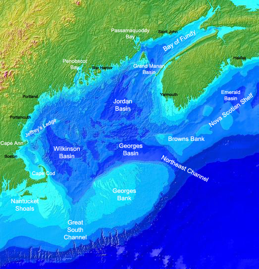
Origin
Found on the english Wikipedia Image :GulfofMaine.jpg. Digital bathymetry map of the Gulf of Maine. Credit: National Oceanographic and Atmospheric Administration and U.S. Geological Survey (USGS) Woods Hole, MA Labels by Syagria.)
Резюме
Digital bathymetry map of the Gulf of Maine. Credit: National Oceanographic and Atmospheric Administration and U.S. Geological Survey (USGS) Woods Hole, MA. Labels by Syagria.
Лицензиране
This image is in the public domain because it contains materials that originally came from the U.S. National Oceanic and Atmospheric Administration, taken or made as part of an employee's official duties.
|
История на файла
Избирането на дата/час ще покаже как е изглеждал файлът към онзи момент.
| Дата/Час | Миникартинка | Размер | Потребител | Коментар | |
|---|---|---|---|---|---|
| текуща | 00:32, 27 ноември 2006 | | 523 × 544 (285 КБ) | TCY | ==Origin== Found on the english Wikipedia [http://en.wikipedia.org/wiki/Image:GulfofMaine.jpg Image :GulfofMaine.jpg] == Summary == Digital bathymetry map of the Gulf of Maine. Credit: National Oceanographic and Atmospheric Administration and U.S. Geolog |
Използване на файла
Следната страница използва следния файл:
Глобално използване на файл
Този файл се използва от следните други уикита:
- Употреба в az.wikipedia.org
- Употреба в be.wikipedia.org
- Употреба в ca.wikipedia.org
- Употреба в ce.wikipedia.org
- Употреба в da.wikipedia.org
- Употреба в en.wikipedia.org
- Употреба в en.wikiversity.org
- Употреба в es.wikipedia.org
- Употреба в eu.wikipedia.org
- Употреба в fa.wikipedia.org
- Употреба в fi.wikipedia.org
- Употреба в fr.wikipedia.org
- Употреба в gl.wikipedia.org
- Употреба в hr.wikipedia.org
- Употреба в id.wikipedia.org
- Употреба в is.wikipedia.org
- Употреба в ka.wikipedia.org
- Употреба в ko.wikipedia.org
- Употреба в lt.wikipedia.org
- Употреба в ml.wikipedia.org
- Употреба в pt.wikipedia.org
- Употреба в ru.wikipedia.org
- Употреба в ta.wikipedia.org
- Употреба в zh.wikipedia.org