ملف:Topography of africa.jpg


حجم هذه المعاينة: 548 × 599 بكسل. الأبعاد الأخرى: 219 × 240 بكسل | 439 × 480 بكسل | 702 × 768 بكسل | 936 × 1٬024 بكسل | 1٬463 × 1٬600 بكسل.
الملف الأصلي (1٬463 × 1٬600 بكسل حجم الملف: 475 كيلوبايت، نوع MIME: image/jpeg)
| هذا ملف من ويكيميديا كومنز. معلومات من صفحة وصفه مبينة في الأسفل. كومنز مستودع ملفات ميديا ذو رخصة حرة. |
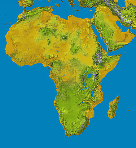
Topography of Africa
image description here:
- PIA04965: SRTM Data Release for Africa, Colored Height
- Elevation data at the highest possible resolution from NASA's SRTM mission in February 2000 are being released for the first time for most of the African continent. This color shaded relief image shows the extent of SRTM digital elevation data for Africa.
- This color shaded relief image shows the extent of digital elevation data for Africa recently released by the Shuttle Radar Topography Mission (SRTM). This release includes data for all of the continent, plus the island of Madagascar and the Arabian Peninsula. SRTM flew on board the Space Shuttle Endeavour in February 2000 and used an interferometric radar system to map the topography of Earth's landmass between latitudes 56 degrees south and 60 degrees north.
larger version here Image credit: NASA/JPL-Caltech
| يقع هذا العمل في النِّطاق العامّ في الولايات المُتحدة الأمريكيَّة لأَنَّه عملٌ خالِصٌ من إِنتاج وكالة الفضاء الأمريكيَّة. تنصُ حقوق التَّأليف والنَّشر الخاصَّة بوكالة الفضاء الأمريكيَّة على أنَّ "أعمال الوكالة غير مَحميَّة بحقوق التَّأليف والنَّشر ما لم يُذكر خلافُ ذلك". لمزيدٍ من المعلومات انظر القالِب {{PD-USGov}} وصفحة حقوق التَّأليف والنَّشر الخاصَّة بالوكالة وصفحة سياسة الصُّور الخاصَّة بمُختبر الدَّفع النَّفَّاث. | ||
 | تنبيهات:
|
تاريخ الملف
اضغط على زمن/تاريخ لرؤية الملف كما بدا في هذا الزمن.
| زمن/تاريخ | صورة مصغرة | الأبعاد | مستخدم | تعليق | |
|---|---|---|---|---|---|
| حالي | 13:01، 27 يناير 2006 | | 1٬463 × 1٬600 (475 كيلوبايت) | Perconte~commonswiki | |
| 10:34، 25 سبتمبر 2005 |  | 552 × 604 (48 كيلوبايت) | ChongDae | This image was copied from wikipedia:en. The original description was: Topography of Africa image description [http://photojournal.jpl.nasa.gov/catalog/PIA04965 here] larger version [http://photojournal.jpl.nasa.gov/jpeg/PIA04965.jpg here] Image credi |
استخدام الملف
ال5 صفحات التالية تستخدم هذا الملف:
الاستخدام العالمي للملف
الويكيات الأخرى التالية تستخدم هذا الملف:
- الاستخدام في cs.wikipedia.org
- الاستخدام في cy.wikipedia.org
- الاستخدام في de.wikipedia.org
- الاستخدام في eml.wikipedia.org
- الاستخدام في eo.wikipedia.org
- الاستخدام في es.wikipedia.org
- الاستخدام في et.wikipedia.org
- الاستخدام في eu.wikipedia.org
- الاستخدام في fa.wikipedia.org
- الاستخدام في hy.wikipedia.org
- الاستخدام في ie.wikipedia.org
- الاستخدام في incubator.wikimedia.org
- الاستخدام في it.wikipedia.org
- الاستخدام في it.wikibooks.org
- الاستخدام في it.wikiversity.org
- الاستخدام في ja.wikipedia.org
- الاستخدام في kab.wikipedia.org
- الاستخدام في ka.wikipedia.org
- الاستخدام في kn.wikipedia.org
- الاستخدام في ko.wikipedia.org
- الاستخدام في lld.wikipedia.org
- الاستخدام في lmo.wikipedia.org
- الاستخدام في ml.wikipedia.org
- الاستخدام في nl.wikipedia.org
- الاستخدام في nrm.wikipedia.org
- الاستخدام في pl.wikipedia.org
- الاستخدام في pms.wikipedia.org
- الاستخدام في qu.wikipedia.org
- الاستخدام في roa-tara.wikipedia.org
- الاستخدام في sk.wikipedia.org
اعرض المزيد من الاستخدام العام لهذا الملف.