ملف:Rita 2005-09-21 1610Z.jpg


حجم هذه المعاينة: 480 × 600 بكسل. الأبعاد الأخرى: 192 × 240 بكسل | 384 × 480 بكسل | 614 × 768 بكسل | 819 × 1٬024 بكسل | 1٬638 × 2٬048 بكسل | 6٬400 × 8٬000 بكسل.
الملف الأصلي (6٬400 × 8٬000 بكسل حجم الملف: 9٫48 ميجابايت، نوع MIME: image/jpeg)
| هذا ملف من ويكيميديا كومنز. معلومات من صفحة وصفه مبينة في الأسفل. كومنز مستودع ملفات ميديا ذو رخصة حرة. |
ملخص
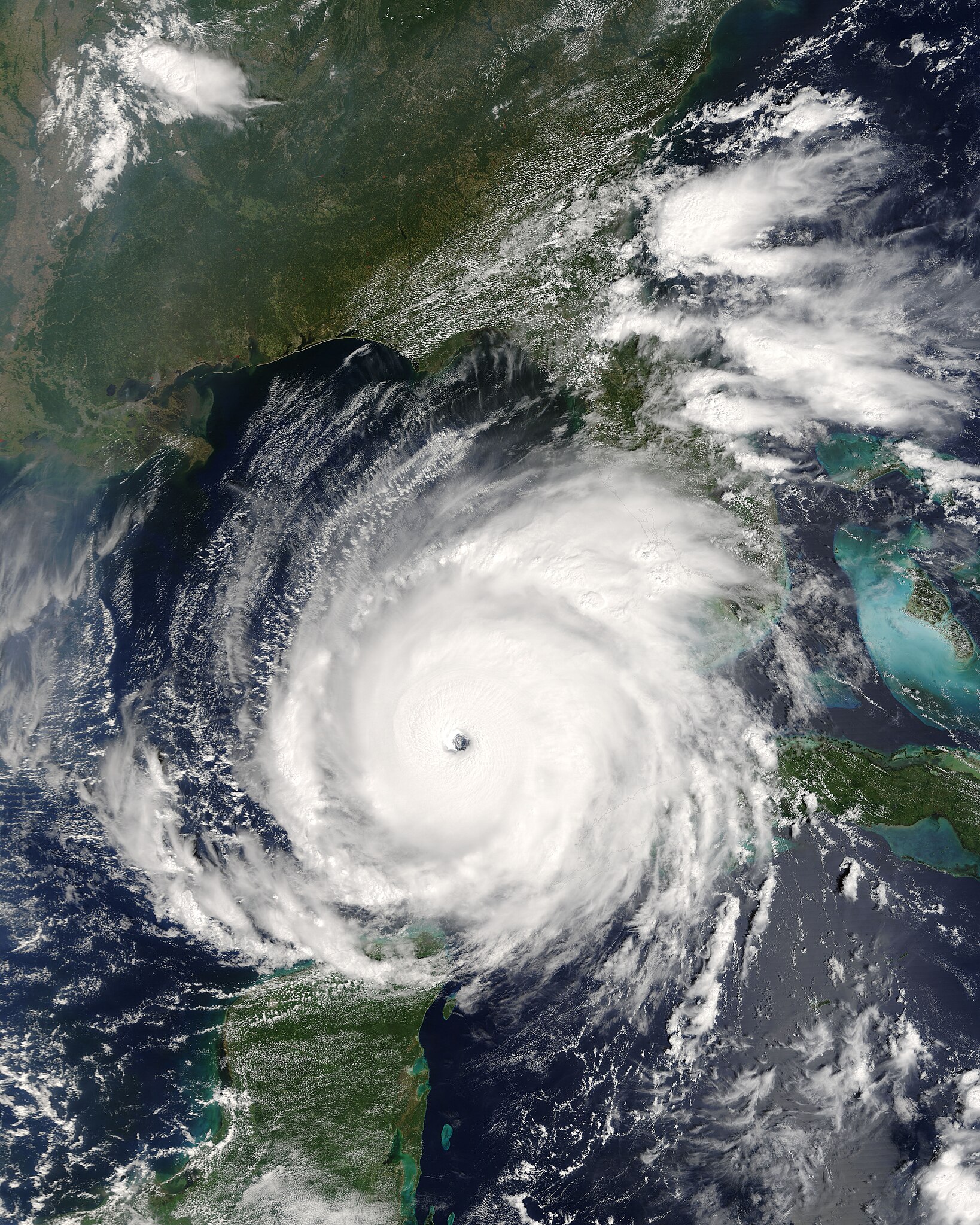
| الوصف | English: Rita was building into an extremely dangerous Category 5 hurricane when the ’ on NASA’s Terra satellite captured this image at 12:10 p.m., U.S. Eastern time on September 21, 2005. The storm bears the markings of a powerful hurricane: it is compact and circular, with an open eye through which the deep blue waters of the Gulf of Mexico are visible. At the time this image was acquired, Rita had winds of 220 kilometers per hour (140 miles per hour) with gusts to 270 kph (170 mph). Within a few hours, the storm intensified to a Category 5 hurricane with sustained winds of 265 kph (165 mph). Rita is the thrird Category 5 storm of the 2005 Atlantic hurricane season. The first was Hurricane Katrina, which devastated much of the Mississippi, Louisiana, and Alabama shoreline when it came ashore on August 29. Rita is expected to weaken slightly before coming ashore over the Texas or Louisiana coastline on September 23 or 24 as a major hurricane (Category 3 or higher). In this photo-like image, the Gulf Coast of the United States frames the open water to the north, while the Yucatan Peninsula is visible to the south. MODIS detected several fires, marked with red dots, burning in the southeastern United States. The fires are probably agricultural fires.Suomi: Hurrikaani Rita lähestymässä Meksikonlahden länsiosaa 21. syyskuuta | |||||
| التاريخ | ||||||
| المصدر | http://visibleearth.nasa.gov/view_rec.php?id=7957 | |||||
| المؤلف | Jacques Descloitres, MODIS Rapid Response Team, NASA/GSFC | |||||
| الترخيص (إعادة استخدام هذا الملف) |
|

تاريخ الملف
اضغط على زمن/تاريخ لرؤية الملف كما بدا في هذا الزمن.
| زمن/تاريخ | صورة مصغرة | الأبعاد | مستخدم | تعليق | |
|---|---|---|---|---|---|
| حالي | 16:29، 26 أغسطس 2006 | | 6٬400 × 8٬000 (9٫48 ميجابايت) | Good kitty | |
| 22:29، 21 سبتمبر 2005 |  | 3٬200 × 4٬000 (3٫25 ميجابايت) | Holderca1~commonswiki | Hurricane Rita near peak intensity as it churns across the Gulf of Mexico, taking aim at the Texas coast. ==Source/Credit== http://earthobservatory.nasa.gov/NaturalHazards/natural_hazards_v2.php3?img_id=13146 NASA image courtesy Jeff Schmaltz, MODIS Lan |
استخدام الملف
الصفحتان التاليتان تستخدمان هذا الملف:
الاستخدام العالمي للملف
الويكيات الأخرى التالية تستخدم هذا الملف:
- الاستخدام في ca.wikipedia.org
- الاستخدام في de.wikipedia.org
- الاستخدام في en.wikipedia.org
- User:Jdorje/2005 Atlantic hurricane season/2005 Atlantic hurricane season storms
- User:Omni ND/Good Pictures
- Portal:Tropical cyclones/Anniversaries/September
- Portal:Tropical cyclones/Anniversaries/September/24
- Climate of Beaumont, Texas
- Wikipedia:Featured picture candidates/March-2008
- Wikipedia:Featured picture candidates/HurricaneRita21Sept05a.jpg
- Portal:Tropical cyclones/Selected image/29
- Wikipedia:Featured picture candidates/Hurricane Rita
- User:Cyclonebiskit/Hurricane Rita
- User:DaBloonsplayer
- User:SuperNascar 1991
- User:Grammarguruguy
- User:40bus/sandbox1
- Portal:Tropical cyclones/Selected image
- الاستخدام في en.wikinews.org
- Hurricane Dennis makes landfall on Gulf Coast near Pensacola
- Mandatory evacuation declared in New Orleans, US
- Template:Hurricane 2005 Infobox
- Template talk:2005 Hurrican Season Infobox
- Template talk:Hurricane 2005 Infobox
- At least 55 killed by Hurricane Katrina; serious flooding across affected region
- Blackwater mercenaries used in New Orleans
- Hurricane Ophelia hits U.S. East Coast
- Tropical Storm Wilma forms, ties record for busiest hurricane season
- Hurricane Wilma becomes stronger on its path toward Florida
- Hurricane Wilma still a Category 5 threat
- Florida Governor Jeb Bush gives speech on Hurricane Wilma
- Tropical Storm Epsilon forms as 2005 Atlantic hurricane season comes to an end
- Tropical Storm Zeta becomes second cross-season tropical storm in history
- Record-breaking 2005 Atlantic Hurricane Season officially ends
- الاستخدام في eo.wikipedia.org
- الاستخدام في es.wikipedia.org
- الاستخدام في eu.wikipedia.org
- الاستخدام في fa.wikipedia.org
- الاستخدام في fi.wikipedia.org
- الاستخدام في fr.wikipedia.org
- الاستخدام في he.wikipedia.org
- الاستخدام في hu.wikipedia.org
- الاستخدام في it.wikipedia.org
- الاستخدام في ko.wikipedia.org
- الاستخدام في nl.wikipedia.org
- الاستخدام في pl.wikipedia.org
- الاستخدام في pt.wikipedia.org
اعرض المزيد من الاستخدام العام لهذا الملف.