ملف:Israeli-Palestinian Railways.svg


الملف الأصلي (ملف SVG، أبعاده 1٬660 × 2٬748 بكسل، حجم الملف: 592 كيلوبايت)
| هذا ملف من ويكيميديا كومنز. معلومات من صفحة وصفه مبينة في الأسفل. كومنز مستودع ملفات ميديا ذو رخصة حرة. |
ملخص
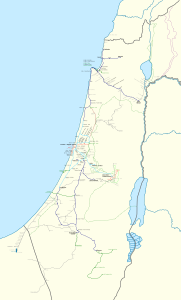
| الوصف | Français : Carte des chemins de fer Israéliens/Palestiniens. English: This map shows all railways that have been operated by Palestine Railways, Israel Railways, or have existed on the territory of Israel/Palestine. Certain sources show more train stations at:
I could not find a secondary source, and so they have been left out. There might also have been a Haifa-Wadi Rushmiya line. The station at Birein was probably more of a simple water refilling stop; this is possibly the same for other former stops in the Negev. The J'slm - El Bireh line was a military railway built by the British in 1918 to supply the war front North of Jerusalem. Very little information is available on it, and so its path is very hypothetical; this is also true for other lines (mostly in the Negev). Names: I tried to put former names where possible (space permitting). A plethora of translations, transliterations, and transcriptions exist when romanising Hebrew and Arabic station names. Since this map is in English, I have preferred the name that appeared the most "English" in my eyes. For clarity, a hyphen "-" is used to separate the town name from a qualifier. Borders: Undisputed borders 1949 Green line 1974 Purple line East Jerusalem municipal borders Train Lines: Open (electrified) Open Open (freight only) Being built Closed |
| التاريخ | |
| المصدر |
|
| المؤلف | Mapeh |
| إصدارات أخرى | A bigger version of this map exists: Israeli-Palestinian Railways (Full).svg. The source code for both is exactly the same: the only differences between the two are the boundaries (this map has smaller boundaries, therefore "cutting off" the empty parts: the Negev, the Sinai, and the Mediterranean), and which layers are visible (this map shows a schematic version of the Sinai Railway, while the full map shows a geographically accurate version). |
.svg)
ترخيص
- يحقُّ لك:
- مشاركة العمل – نسخ العمل وتوزيعه وبثُّه
- إعادة إنتاج العمل – تعديل العمل
- حسب الشروط التالية:
- نسب العمل إلى مُؤَلِّفه – يلزم نسب العمل إلى مُؤَلِّفه بشكل مناسب وتوفير رابط للرخصة وتحديد ما إذا أجريت تغييرات. بالإمكان القيام بذلك بأية طريقة معقولة، ولكن ليس بأية طريقة تشير إلى أن المرخِّص يوافقك على الاستعمال.
- الإلزام بترخيص المُشتقات بالمثل – إذا أعدت إنتاج المواد أو غيرت فيها، فيلزم أن تنشر مساهماتك المُشتقَّة عن الأصل تحت ترخيص الأصل نفسه أو تحت ترخيص مُتوافِقٍ معه.
تاريخ الملف
اضغط على زمن/تاريخ لرؤية الملف كما بدا في هذا الزمن.
| زمن/تاريخ | صورة مصغرة | الأبعاد | مستخدم | تعليق | |
|---|---|---|---|---|---|
| حالي | 20:33، 16 سبتمبر 2023 | | 1٬660 × 2٬748 (592 كيلوبايت) | Crash48 | Eastern Railway being rebuilt: https://www.jpost.com/business-and-innovation/article-738891 |
| 06:22، 23 أغسطس 2023 |  | 1٬660 × 2٬748 (592 كيلوبايت) | Crash48 | +names of Bnei Brak – Ramat HaHayal (Tel Aviv – North) | |
| 08:39، 22 أغسطس 2023 |  | 1٬660 × 2٬748 (591 كيلوبايت) | Crash48 | Netanya-Lod-Ashkelon electrified | |
| 19:48، 21 أغسطس 2023 |  | 1٬660 × 2٬748 (591 كيلوبايت) | Crash48 | +Dor/Tantura, Zikhron Yaakov, Jaffa Docks | |
| 22:26، 18 أغسطس 2023 |  | 1٬660 × 2٬748 (588 كيلوبايت) | Crash48 | +Red LRT lines | |
| 10:20، 4 يونيو 2022 |  | 1٬660 × 2٬748 (567 كيلوبايت) | Glide08 | Updated to mark the Herzliya-Sharon-Ashkelon and Jerusalem-Modi'in electrified lines | |
| 23:05، 3 نوفمبر 2021 |  | 1٬660 × 2٬748 (566 كيلوبايت) | Glide08 | Updated to mark electrified lines as a separate color, and reflect on the extension of the Sharon Railway to Herzliya and the closure of the Beit Shemesh-Malha railway. | |
| 17:41، 2 مايو 2020 |  | 1٬660 × 2٬748 (574 كيلوبايت) | Mapeh | Minor: fixed color of Mazkeret Batya station label | |
| 18:43، 17 مارس 2020 |  | 1٬660 × 2٬748 (551 كيلوبايت) | Mapeh | Corrected the color of Mazkeret Batya station | |
| 14:32، 18 أغسطس 2019 |  | 1٬660 × 2٬748 (574 كيلوبايت) | My another account | 1) w:Mazkeret Batya railway station opened on 30/05/2019; 2) Change font for Nahariya to mark it as terminus; 3) Wilhelma was a separate station from Rantiya; 4) Tzrifin and Tel HaShomer stations were out of use by the time these settlements got their modern names. |
استخدام الملف
ال3 صفحات التالية تستخدم هذا الملف:
الاستخدام العالمي للملف
الويكيات الأخرى التالية تستخدم هذا الملف:
- الاستخدام في de.wikipedia.org
- الاستخدام في en.wikipedia.org
- الاستخدام في he.wikipedia.org
- الاستخدام في hu.wikipedia.org
- الاستخدام في ru.wikipedia.org
- الاستخدام في www.wikidata.org