ملف:Hungarian autonomous province02.png

حجم هذه المعاينة: 619 × 599 بكسل. الأبعاد الأخرى: 248 × 240 بكسل | 496 × 480 بكسل | 751 × 727 بكسل.
الملف الأصلي (751 × 727 بكسل حجم الملف: 60 كيلوبايت، نوع MIME: image/png)
| هذا ملف من ويكيميديا كومنز. معلومات من صفحة وصفه مبينة في الأسفل. كومنز مستودع ملفات ميديا ذو رخصة حرة. |
 | هذه map الصورة / الصورتان باستعمال رسومات متجهية ملفات رسوميات شعاعية. It is recommended to name the SVG file "Hungarian autonomous province02.svg" - then the template Vector version available (or Vva) does not need the new image name parameter. |
ملخص
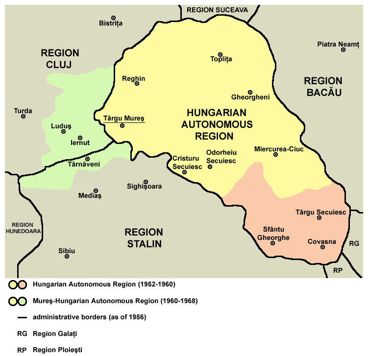
| الوصف | English: Map of the Hungarian Autonomous Region / Magyar Autonomous Region (1952-1960) and Mureş-Hungarian Autonomous Region / Mureş-Magyar Autonomous Region (1960-1968). |
| التاريخ | |
| المصدر | Transferred from en.wikipedia |
| المؤلف | PANONIAN (نقاش · مساهمات) |
ترخيص
| أنا، مالِك حقوق تأليف ونشر هذا العمل، أجعله في النِّطاق العامِّ، يسري هذا في أرجاء العالم كلِّه. في بعض البلدان، قد يكون هذا التَّرخيص غيرَ مُمكنٍ قانونيَّاً، في هذه الحالة: أمنح الجميع حق استخدام هذا العمل لأي غرض دون أي شرط ما لم يفرض القانون شروطًا إضافية. |
 | This map has been uploaded by Electionworld from en.wikipedia.org to enable the |
References
Primary reference:
Secondary references:
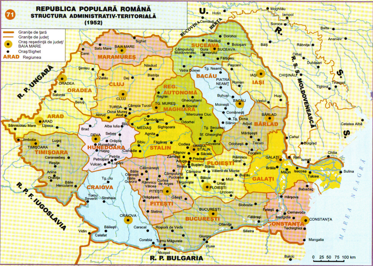
- http://www.adevarul.ro/bbtcontent/clipping/ADVIMA20110612_0443/1.jpg
- http://www.hungarian-human-rights.eu/images/rpr_1952.jpg
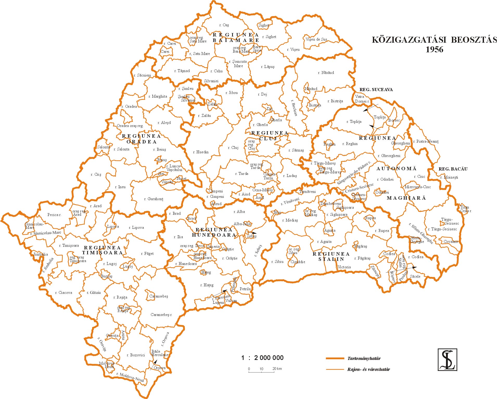
- http://sebok1.adatbank.transindex.ro/kepek/erd1956.jpg
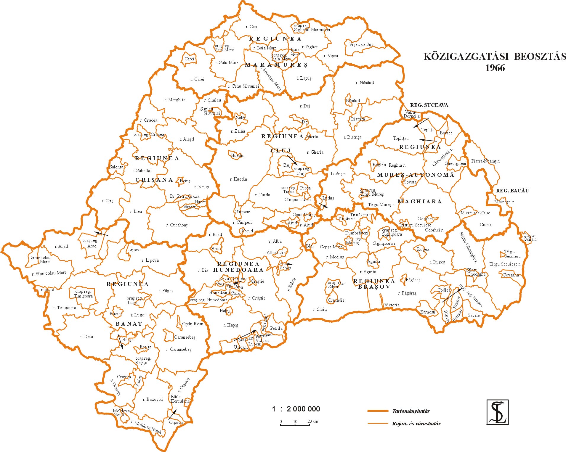
- http://sebok1.adatbank.transindex.ro/kepek/erd1966.jpg
- http://2.bp.blogspot.com/_yYcDY0o6YEA/SXaL1dSAXGI/AAAAAAAAAFk/21nu4zMSKJ8/s600/RO1960-1968.jpg
تاريخ الملف
اضغط على زمن/تاريخ لرؤية الملف كما بدا في هذا الزمن.
| زمن/تاريخ | صورة مصغرة | الأبعاد | مستخدم | تعليق | |
|---|---|---|---|---|---|
| حالي | 18:59، 26 مارس 2013 | | 751 × 727 (60 كيلوبايت) | PANONIAN | Reverted to version as of 13:05, 24 October 2011 I do not agree with your changes, please upload your file under different name |
| 09:09، 26 مارس 2013 |  | 619 × 599 (103 كيلوبايت) | Rgvis | Improved version with administrative borders changes shown during the existance of the Soviet-inspired administrative and territorial organisation in Communist Romania (1950-1968). | |
| 13:05، 24 أكتوبر 2011 |  | 751 × 727 (60 كيلوبايت) | PANONIAN | improved version | |
| 18:56، 28 ديسمبر 2006 |  | 716 × 620 (11 كيلوبايت) | Electionworld | {{ew|en|PANONIAN}} map of the Hungarian Autonomous Province (self made) {{PD-self}} Category:Maps of the history of Romania |
استخدام الملف
الصفحة التالية تستخدم هذا الملف:
الاستخدام العالمي للملف
الويكيات الأخرى التالية تستخدم هذا الملف:
- الاستخدام في be.wikipedia.org
- الاستخدام في bg.wikipedia.org
- الاستخدام في ca.wikipedia.org
- الاستخدام في en.wikipedia.org
- الاستخدام في es.wikipedia.org
- الاستخدام في fr.wikipedia.org
- الاستخدام في hu.wikipedia.org
- الاستخدام في it.wikipedia.org
- الاستخدام في mk.wikipedia.org
- الاستخدام في nl.wikipedia.org
- الاستخدام في pl.wikipedia.org
- الاستخدام في pt.wikipedia.org
- الاستخدام في ro.wikipedia.org
- الاستخدام في ru.wikipedia.org
- الاستخدام في sl.wikipedia.org
- الاستخدام في sr.wikipedia.org
- الاستخدام في uk.wikipedia.org
- الاستخدام في www.wikidata.org