ملف:British Decolonisation in Africa.png

حجم هذه المعاينة: 600 × 600 بكسل. الأبعاد الأخرى: 240 × 240 بكسل | 480 × 480 بكسل | 768 × 768 بكسل | 1٬024 × 1٬024 بكسل | 2٬000 × 2٬000 بكسل.
الملف الأصلي (2٬000 × 2٬000 بكسل حجم الملف: 406 كيلوبايت، نوع MIME: image/png)
| هذا ملف من ويكيميديا كومنز. معلومات من صفحة وصفه مبينة في الأسفل. كومنز مستودع ملفات ميديا ذو رخصة حرة. |
ملخص
 | هذه historical map الصورة / الصورتان باستعمال رسومات متجهية ملفات رسوميات شعاعية. It is recommended to name the SVG file "British Decolonisation in Africa.svg" - then the template Vector version available (or Vva) does not need the new image name parameter. |
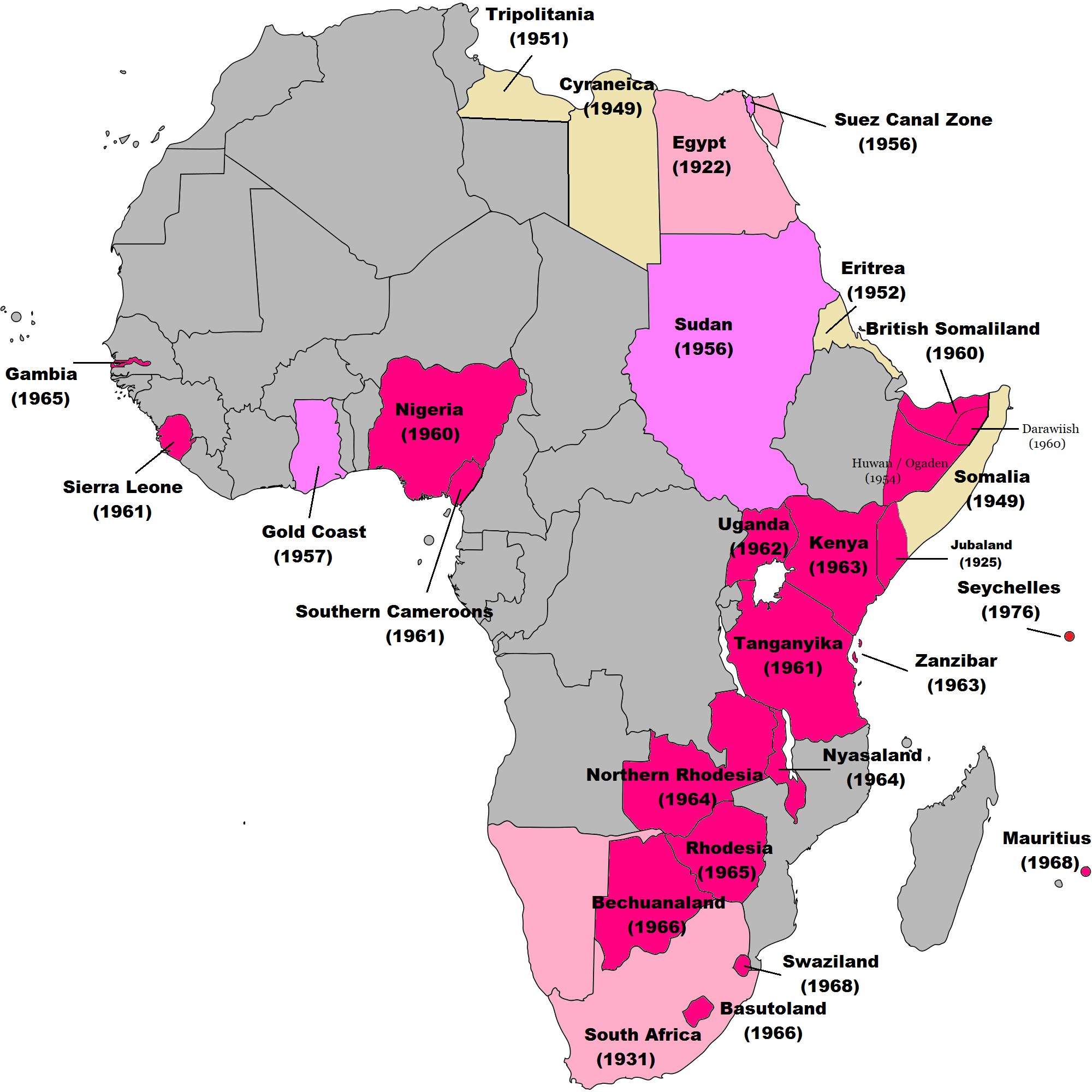
| الوصف | English: Map of British decolonisation in Africa. The beige areas were under British military administration after WW2. The different shades of pink refer to the stages of decolonization according to decades. |
| التاريخ | ١ نوفمبر ٢٠٠٨ (تاريخ الرفع الأصيل) |
| المصدر | Transferred from en.wikipedia; transfer was stated to be made by User:Hejsa. Blank map from File:BlankMap-World3.svg . Original text:
|
| المؤلف | The Red Hat of Pat Ferrick t (log) |
| الترخيص (إعادة استخدام هذا الملف) | Released into the public domain (by the author). |
ترخيص
| | وُضِعت هذه الصُّورة في النِّطاق العامّ مِن قبل مُؤَلِّفها، The Red Hat of Pat Ferrick في مشروع Wikimedia Commons. ويسري هذا في جميع أَنحاء العالم. إِذا لم يكن النِّطاق العام مُمكِناً مِن النَّاحية القانونيَّة:
|
سجلُّ الرَّفع الأصيل
صفحة الوصف الأصلية كانت هنا، تشير جميع أسماء المستخدمين التالية إلى en.wikipedia.
- 2008-11-02 00:56 The Red Hat of Pat Ferrick 757×785× (171674 bytes) {{Information |Description=Map of British decolonisation in Africa. |Source=I created this work entirely by myself. |Date=1 November 2008 |Author=~~~ |other_versions= }}
تاريخ الملف
اضغط على زمن/تاريخ لرؤية الملف كما بدا في هذا الزمن.
| زمن/تاريخ | صورة مصغرة | الأبعاد | مستخدم | تعليق | |
|---|---|---|---|---|---|
| حالي | 08:49، 8 نوفمبر 2021 | | 2٬000 × 2٬000 (406 كيلوبايت) | Randomastwritter | ogaden |
| 03:23، 30 أكتوبر 2021 |  | 2٬000 × 2٬000 (399 كيلوبايت) | Randomastwritter | juba | |
| 01:38، 7 ديسمبر 2013 |  | 2٬000 × 2٬000 (396 كيلوبايت) | Zello | corrected map that better reflects historical realities (for example South-West Africa, Rhodesia), also Mauritius and Seychelle added, and new colour for territories under temporary military administration after WW2 | |
| 18:52، 22 نوفمبر 2013 |  | 757 × 785 (159 كيلوبايت) | Zello | Somalia became a UN Trust Territory under Italian administration in 1949. The correction was requested also on the talk page. | |
| 16:08، 13 سبتمبر 2009 |  | 757 × 785 (168 كيلوبايت) | Hejsa | {{Information |Description={{en|Map of British decolonisation in Africa.}} |Source=Transferred from [http://en.wikipedia.org en.wikipedia]; transfer was stated to be made by User:Hejsa. |Date=1 November 2008<br/> ({{Date|2008|11|02}} (original upload |
استخدام الملف
ال3 صفحات التالية تستخدم هذا الملف:
الاستخدام العالمي للملف
الويكيات الأخرى التالية تستخدم هذا الملف:
- الاستخدام في ast.wikipedia.org
- الاستخدام في azb.wikipedia.org
- الاستخدام في az.wikipedia.org
- الاستخدام في ba.wikipedia.org
- الاستخدام في cs.wikipedia.org
- الاستخدام في da.wikipedia.org
- الاستخدام في de.wikipedia.org
- الاستخدام في el.wikipedia.org
- الاستخدام في en.wikipedia.org
- الاستخدام في eu.wikipedia.org
- الاستخدام في fr.wikipedia.org
- الاستخدام في fr.wikiversity.org
- الاستخدام في hy.wikipedia.org
- الاستخدام في id.wikipedia.org
- الاستخدام في it.wikipedia.org
- الاستخدام في ka.wikipedia.org
- الاستخدام في ko.wikipedia.org
- الاستخدام في lv.wikipedia.org
- الاستخدام في ms.wikipedia.org
- الاستخدام في nl.wikipedia.org
- الاستخدام في no.wikipedia.org
- الاستخدام في pl.wikipedia.org
- الاستخدام في pt.wikipedia.org
- الاستخدام في ru.wikipedia.org
- الاستخدام في th.wikipedia.org
- الاستخدام في tr.wikipedia.org
- الاستخدام في uk.wikipedia.org
- الاستخدام في uz.wikipedia.org
- الاستخدام في vi.wikipedia.org
اعرض المزيد من الاستخدام العام لهذا الملف.