ملف:Abbasids786-809.png


حجم هذه المعاينة: 800 × 487 بكسل. الأبعاد الأخرى: 320 × 195 بكسل | 640 × 390 بكسل | 1٬024 × 624 بكسل | 1٬481 × 902 بكسل.
الملف الأصلي (1٬481 × 902 بكسل حجم الملف: 30 كيلوبايت، نوع MIME: image/png)
| هذا ملف من ويكيميديا كومنز. معلومات من صفحة وصفه مبينة في الأسفل. كومنز مستودع ملفات ميديا ذو رخصة حرة. |
ملخص
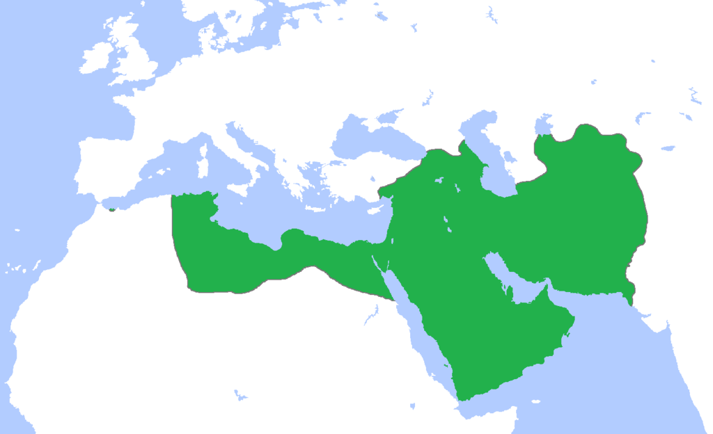
| الوصف | English: Map of the Abbasid Caliphate at its greatest extent, c. 786-809. (Partially based on Atlas of World History (2007) - Progress of Islam, map) |
| التاريخ | |
| المصدر | عمل شخصي |
| المؤلف | Gabagool |
ترخيص
أنا، صاحب حقوق التأليف والنشر لهذا العمل، أنشر هذا العمل تحت الرخصة التالية:
هذا الملف مُرخص تحت رخصة المشاع المبدع نسبة المصنف إلى مؤلفه 3.0 العامة
- يحقُّ لك:
- مشاركة العمل – نسخ العمل وتوزيعه وبثُّه
- إعادة إنتاج العمل – تعديل العمل
- حسب الشروط التالية:
- نسب العمل إلى مُؤَلِّفه – يلزم نسب العمل إلى مُؤَلِّفه بشكل مناسب وتوفير رابط للرخصة وتحديد ما إذا أجريت تغييرات. بالإمكان القيام بذلك بأية طريقة معقولة، ولكن ليس بأية طريقة تشير إلى أن المرخِّص يوافقك على الاستعمال.
تاريخ الملف
اضغط على زمن/تاريخ لرؤية الملف كما بدا في هذا الزمن.
| زمن/تاريخ | صورة مصغرة | الأبعاد | مستخدم | تعليق | |
|---|---|---|---|---|---|
| حالي | 22:25، 4 أغسطس 2016 | | 1٬481 × 902 (30 كيلوبايت) | Omar-toons | Bahrain to Abbasids + the Emirate of Nekor recognized the Abbasid caliphs as its suzerains |
| 16:35، 17 مارس 2012 |  | 1٬481 × 902 (50 كيلوبايت) | Cplakidas | Corrections: the conquest of Sicily began in the 820s, and Corsica and Sardinia were only raided and at most temporarily occupied, and then far later than the period given here | |
| 20:37، 15 مايو 2009 |  | 1٬481 × 902 (50 كيلوبايت) | Gabagool | {{Information |Description={{en|1=Map of the Abbasid Caliphate at its greatest extent, c. 786-809. (Partially based on ''Atlas of World History'' (2007) - Progress of Islam, map)}} |Source=Own work by uploader |Author=Gabagool / Jarle G |
استخدام الملف
الصفحة التالية تستخدم هذا الملف:
الاستخدام العالمي للملف
الويكيات الأخرى التالية تستخدم هذا الملف:
- الاستخدام في ba.wikipedia.org
- الاستخدام في en.wikipedia.org
- الاستخدام في fr.wikipedia.org
- الاستخدام في it.wikipedia.org
- الاستخدام في nl.wikipedia.org
- الاستخدام في oc.wikipedia.org
- الاستخدام في ru.wikipedia.org
- الاستخدام في simple.wikipedia.org