ملف:1801 Cary Map of the World on Mercator Projection - Geographicus - WorldMerc-cary-1801.jpg


حجم هذه المعاينة: 674 × 600 بكسل. الأبعاد الأخرى: 270 × 240 بكسل | 539 × 480 بكسل | 863 × 768 بكسل | 1٬150 × 1٬024 بكسل | 2٬301 × 2٬048 بكسل | 5٬000 × 4٬451 بكسل.
الملف الأصلي (5٬000 × 4٬451 بكسل حجم الملف: 7٫15 ميجابايت، نوع MIME: image/jpeg)
| هذا ملف من ويكيميديا كومنز. معلومات من صفحة وصفه مبينة في الأسفل. كومنز مستودع ملفات ميديا ذو رخصة حرة. |
| John Cary: A New Chart of the World, on Mercator's Projection: Exhibiting the Track & Discoveries of themost Eminent Navigators, to the Present Period. ( | ||||||||||||||||||||||||||
|---|---|---|---|---|---|---|---|---|---|---|---|---|---|---|---|---|---|---|---|---|---|---|---|---|---|---|
| الفنان |
| |||||||||||||||||||||||||
| العنوان | A New Chart of the World, on Mercator's Projection: Exhibiting the Track & Discoveries of themost Eminent Navigators, to the Present Period. | |||||||||||||||||||||||||
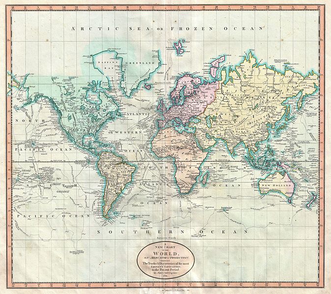
| الوصف | English: John Cary’s wonderful 1801 Map of the World on Mercator’s Projection. Details the entire world as it was known at the turn of the 19th century. Displays the continents in considerable detail but offers only minimal information in the Arctic and Antarctic latitudes. Designed to illustrate the explorations of the previous century, focusing specifically on the important explorations of Cook, Vancouver, Perouse, and Gores. Offers copious notations on explorations and unconfirmed discoveries throughout. Prepared in 1801 by John Cary for issue in his magnificent 1808 New Universal Atlas . | |||||||||||||||||||||||||
| التاريخ | ١٨٠١ (dated) | |||||||||||||||||||||||||
| الأبعاد | ارتفاع: ١٨٫٢ إنش (٤٦٫٣ سم)؛ عرض: ٢٠٫٢ إنش (٥١٫٤ سم) | |||||||||||||||||||||||||
| رقم التصنيف | وصلة موقع جيوغرافيكوس: WorldMerc-cary-1801 | |||||||||||||||||||||||||
| المصدر/المصور | Cary, John, Cary's New Universal Atlas, containing distinct maps of all the principal states and kingdoms throughout the World. From the latest and best authorities extant. London: Printed for J. Cary, Engraver and Map-seller, No. 181, near Norfolk Street, Strand, 1808.
| |||||||||||||||||||||||||
| الترخيص (إعادة استخدام هذا الملف) |
| |||||||||||||||||||||||||
تاريخ الملف
اضغط على زمن/تاريخ لرؤية الملف كما بدا في هذا الزمن.
| زمن/تاريخ | صورة مصغرة | الأبعاد | مستخدم | تعليق | |
|---|---|---|---|---|---|
| حالي | 09:45، 22 مارس 2011 | | 5٬000 × 4٬451 (7٫15 ميجابايت) | BotMultichill | {{subst:User:Multichill/Geographicus |link=http://www.geographicus.com/P/AntiqueMap/WorldMerc-cary-1801 |product_name=1801 Cary Map of the World on Mercator Projection |map_title=A New Chart of the World, on Mercator's Projection: Exhibiting the Track & |
استخدام الملف
الصفحة التالية تستخدم هذا الملف:
الاستخدام العالمي للملف
الويكيات الأخرى التالية تستخدم هذا الملف:
- الاستخدام في en.wikipedia.org
- الاستخدام في fr.wikipedia.org
- الاستخدام في it.wikipedia.org
- الاستخدام في pt.wikipedia.org