Roztocze

Roztocze (Ukrainian: Розточчя, romanized: Roztochchia) is a range of hills in east-central Poland and western Ukraine which rises from the Lublin Upland and extends southeastward through Solska Forest and across the border into Ukrainian Podolia. Low and rolling, the range is approximately 180 km long and 14 km wide. Its highest peak within Poland is Wielki Dział at 390 meters, while in Ukraine it is Vysokyi Zamok (Lviv High Castle) at 409 m. In Poland Roztocze lies in the Lublin and Podkarpackie voivodships, while the portion in Ukraine extends all the way to the outskirts of Lviv. In 2011 UNESCO established the Roztochia Biosphere Reserve. The Polish portion of the range makes up the Roztocze National Park.

Inhabitation[edit]
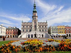
Main cities and towns of the Roztocze range include: Biłgoraj, Hrubieszów, Janów Lubelski, Józefów, Krasnobród, Kraśnik, Lubaczów, Narol, Nemyriv, Szczebrzeszyn, Tomaszów Lubelski, Yavoriv, Zamość, Zhovkva, and Zwierzyniec.
Geology and Formation of the Roztocze Region[edit]
The Roztocze is a range of hills extending from Kraśnik in Poland to Lviv in Ukraine. Its formation is closely related to tectonic movements that occurred during the Mesozoic era. In the Cretaceous period (approximately 100 million years ago), this area was the floor of a shallow sea where limestone, marl, and sandstone were deposited. At the end of the Cretaceous, as a result of orogenic movements, this area was uplifted, creating the current geological structures. [1]
Early Human History[edit]
The first traces of human settlement in the Roztocze region date back to the Paleolithic era. Numerous stone tools found in the area indicate the presence of humans as early as 100,000 years ago. In the Neolithic period (around 6,000 years ago), the first agricultural settlements appeared. During the Roman influence period (1st-4th century AD), the Amber Road, connecting northern Europe with the Roman Empire, passed through Roztocze. [2]
Medieval and Modern History[edit]
In the Middle Ages, Roztocze was a battleground between various Slavic tribes. In the 10th century, the area was incorporated into the Piast state and found itself within the borders of Kievan Rus. In the 14th century, after the conquests of Casimir the Great, Roztocze was annexed to the Kingdom of Poland. During this period, numerous defensive castles were built, such as the castles in Szczebrzeszyn and Zamość, to protect the region from invasions. In the 17th century, Roztocze became part of the Polish-Lithuanian Commonwealth, and after the partitions of Poland (1772-1795), it was divided between Austria, Prussia, and Russia. [3] In the 19th century, the region experienced dynamic economic development, primarily due to the construction of railways and the development of the oil industry in Galicia. [4]
20th Century: Wars and Resettlements[edit]
In the interwar period, Roztocze was part of Poland and became a popular holiday destination. During World War II, the region was the site of intense fighting and partisan operations. After the war, due to border shifts, Roztocze was divided between Poland and the Soviet Union (now Ukraine). During this period, there were mass resettlements. As part of Operation Vistula (1947), thousands of Ukrainians, Lemkos, Boykos, and Hutsuls were resettled from southeastern Poland to the so-called Recovered Territories. Simultaneously, Poles from the Eastern Borderlands (now Ukraine, Belarus, and Lithuania) were resettled to the Recovered Territories in Poland. [5]
Roztocze National Park[edit]
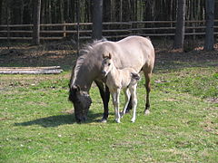
Roztocze National Park, established in 1974, is one of the most important protected areas in Poland. It encompasses a variety of ecosystems, including forests, meadows, peat bogs, and rivers. The park is home to many species of plants and animals, including rare and protected species such as the wildcat, wolf, lesser spotted eagle, and many others. [6]
Points of interest in Roztocze region[edit]
-

-
-
-
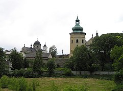
 A pond with a church on an island, Zwierzyniec.
 -

-

-

-
-

-

-


References[edit]
- ^ Dobrowolski, Radosław, Marian Harasimiuk, and Teresa Brzezińska-Wójcik. "Strukturalne uwarunkowania rzeźby Wyżyny Lubelskiej i Roztocza." Przegląd Geologiczny 62.1 (2014).
- ^ Brzezińska-Wójcik, Teresa, Ewa Skowronek, and Piotr Kondraciuk. "Możliwości wykorzystania dziedzictwa ośrodków kamieniarskich Roztocza w turystyce." Uwarunkowania i plany rozwoju turystyki. Turystyka i Rekreacja–Studia i Prace 15 (2015).
- ^ Buraczyński J., Roztocze. Dzieje osadnictwa, Lublin 2008.
- ^ Franciszek Bujak: Galicya. Kraj, ludność, społeczeństwo, rolnictwo. T. 1. Lwów: 1908
- ^ Motyka, G. (1999). "Tak było w Bieszczadach. Walki polsko-ukraińskie 1943-1948". Oficyna Wydawnicza VOLUMEN.
- ^ Roman Reszel, Tadeusz Grądziela (red.): Roztoczański Park Narodowy. Przyroda i człowiek. Wyd. I. Zwierzyniec: Roztoczański Park Narodowy, 2013.
- Information about the region from www.roztocze.com
- Information service about Roztocze (in Polish)
- Information service and photo gallery about Roztocze (in Polish)
- Roztocze landscapes - Fine Art Photography by Tomasz Dziubinski
- Roztocze landscapes - Photography by Jola Dziubinska
- Roztocze architecture - Fine Art Photography by Tomasz Dziubinski
- Roztocze places - Photography by Jola Dziubinska
- Roztocze places - Photography by mojeroztocze.pl
- Ukrainian Roztochia
- UNESCO Biosphere in 2011
| International | |
|---|---|
| National | |
This article about a location in Lviv Oblast is a stub. You can help Wikipedia by expanding it. |
This Podkarpackie Voivodeship location article is a stub. You can help Wikipedia by expanding it. |
This Lublin Voivodeship location article is a stub. You can help Wikipedia by expanding it. |